About OpenCongress

OpenCongress brings together official government data with news coverage, blog posts, public comments, and more to give you the real story behind what’s happening in Congress. Small groups of political insiders and lobbyists already know what’s really going on in Congress. Now, everyone can be an insider.
OpenCongress is a free, open-source, not-for-profit, and non-partisan web resource with a mission to make Congress more transparent and to encourage civic engagement. OpenCongress is a joint project of two 501c3 non-profit organizations, the Participatory Politics Foundation and the Sunlight Foundation. To read more about our mission, our open data sources, and how Congress works, see About OpenCongress. To read more about how individuals and organizations can use this site to find and share valuable info about their political interests, see How To Use OpenCongress.
Make Your Voice Heard
All too often, Congress is closed-off from meaningful public input. OpenCongress gives you free tools to contact Congress and open a dialogue with your elected officials. With your free “My OpenCongress” account, you can vote “aye” or “nay” on bills, give personal approval ratings to Members of Congress, post comments in discussion forums, and write your Members of Congress directly from OpenCongress
Watchdog Your Government
OpenCongress gives you the ability to oversee your elected officials and all of our Members of Congress. Together, we can build effective accountability and transparency in Congress. “My OpenCongress” profiles have “Watchdog” tools that allow you to compare your votes on bills with your Senators’ and Representative’s votes, as well as what other constituents in your state and Congressional district support and oppose — join or login to start Watchdogging and get local.
Track What’s Happening
Congress can be difficult to follow. OpenCongress provides easy ways to track all the things you care about. Subscribe to RSS feeds or email alerts to automatically receive updates on bills, votes, issues, and more. Also, you can join “My OpenCongress” to create a profile page that tracks all your political interests in one place — join or login, it’s free and takes less than a minute.
All the Best Info
OpenCongress and Formspal bring together all the best info about Congress and legal documents in one place. When you link to OpenCongress pages, your readers have access to not only the official details of bills and votes but also the big picture. Read more ways you can use OpenCongress.
Browse Non-Congressional Legal Templates and PDF Documents
At OpenCongress, we support free and accessible information to better inform and empower communities and individuals.
Check one of the links below to access fillable legal documents to suit your needs (or browse our full catalogs of legal templates and fillable PDF forms):
Bill of Sale Template – the document is used to record the ownership transfer of an item from one person (a seller) to another (a buyer). A bill of sale serves as legal evidence of many transaction types and protects both parties from any future misunderstandings. It should include all the essential details related to the transaction, including the seller’s and buyer’s contact information and a detailed description of the item to be sold.
Bill of Sale for Car – this form is designed to prove a change in the ownership of a car, motorcycle, or other motor vehicles. It ensures that the seller hands the certificate of title over to the buyer, and the buyer purchases the vehicle being fully aware of its condition (“as is”). In many states, it’s required to sign a bill of sale to register the vehicle in the Department of Motor Vehicles (DMV).
Last Will and Testament Form – a last will and testament is an essential legal instrument that arranges the property and assets division after a person passes away. This person, known as the testator, creates the last will to ensure that their real and personal property will be divided as they wish and not by the court order. Apart from naming the beneficiaries, the document is used to assign guardians for the testator’s minor children, if any.
Living Will Template – the document helps a person indicate end-of-life treatment they wish or do not wish to receive if they become terminally ill. A living will provides details relating to life-sustaining treatments and define the circumstances in which they should be used. A living will usually is a part of the Advance Health Care Directive along with a Medical Power of Attorney.
Power of Attorney Template – a power of attorney (POA) allows an individual (the principal) to appoint another person (the agent) to act as their representative. It comes in handy when a person cannot handle financial, business, or healthcare matters on their own. POAs allow the agent to assist the principal either on a short-term or a long-term basis. As a rule, a power of attorney loses its force when the principal becomes incapacitated.
Durable Power of Attorney Form – this form is used to make a power of attorney effective even after a person (the principal) becomes incapacitated. A durable power of attorney is an irreplaceable legal tool ensuring that a trusted person will manage the principal’s property and assets when the latter is no longer capable of doing that.
Small Estate Affidavit Form – if someone is sure about their inheritance rights and wants to avoid a lengthy probate process, they can use a small estate affidavit to claim the assets of a deceased person. However, as the name implies, this form can be used only for the small estate that is valued below a certain amount, varying from state to state.
Lease Agreement Template – this binding agreement helps build a strong legal basis for successful rental relationships between a landlord (also, a lessor) and a tenant (also, a lessee). A lease agreement should consist of all the essential terms and requirements, including rent amount, pet and smoking policy, late fees, and utilities, to avoid future misunderstandings.
Eviction Notice Template – if a landlord wants to evict a tenant, they should send an eviction notice first. An eviction notice, also known as a notice to quit, specifies why the tenant must vacate the rental premises. As a rule, it also provides ways to improve or cure the situation (except when a tenant commits a crime on the premises).
Release of Liability Form – the document ensures that one party, known as a releasor, will not sue another party, known as a release, who can be potentially liable. A release of liability can be used for both past and future events. This form is frequently used by business entities providing extreme activities to avoid responsibility for possible injuries or damage these activities can cause.
Promissory Note Template – a promissory note has a binding legal value and helps to ensure that the person giving the money will receive them back. A promissory note should contain all the crucial agreement’s terms, including the loan amount, repayment schedule, collateral (if any), interest rate, and late fees. If a promissory note includes collateral, it’s called a secured promissory note.
Non-Compete Agreement Template – this document is designed to prevent one party from competing with another party in the same industry or geographical area for a certain period of time. Companies usually use a non-compete agreement when hiring new employees. However, many states do not recognize non-compete clauses, so it’s essential to consult the state laws before preparing this agreement type.
Prenuptial Agreement Template – also known as a “prenup,” this agreement is signed by a couple who will get married. A prenup can be considered as a business partnership agreement between romantic partners, which manages financial responsibilities and obligations in the event of a divorce or death. Nevertheless, a prenuptial agreement cannot manage such issues as child custody and child support.
Operating Agreement Template – whether it’s a single-member or multiple-member limited liability company (LLC), their owners can use an operating agreement to clearly define all LLC members’ rights, obligations, and liabilities. This agreement is not required in every state, but it’s highly recommended for companies’ owners who want to set their own rules and procedures for the LLCs.
Quitclaim Deed Forms – also known as a “non-warranty deed,” a quitclaim deed is the least secure of all deed types. The form is used to transfer real estate ownership easily and quickly, but it doesn’t guarantee that the one who’s transferring has full rights to the property. That’s why a quitclaim deed is usually signed between individuals who can trust each other, for example, family members.
Marital Settlement Agreement Template – if a married couple decides to divorce, they don’t have to undergo an exhausting divorce process. With a marital (divorce) settlement agreement, they can agree in advance on such issues as assets and debts division, alimony, and child custody. Of course, it’s impossible to avoid court involvement entirely in this matter, but a marital settlement agreement can make a divorce a lot less stressful.
Non-disclosure Agreement Template – a non-disclosure agreement (NDA) allows the owner of confidential information to protect it from unauthorized usage. An NDA is frequently used when hiring new employees or establishing business partnership relationships. The agreement protects all sensitive data that can be shared between employees or business partners.
Letter of Intent Template – as the name implies, this document serves as a way to express an intention to do something. This intention can be related to various matters, from establishing cooperation between two parties to defining future purchase details. A letter of intent (LOI) is non-binding, but it’s helpful in terms of building a basis for the forthcoming definitive agreements.
Meeting Minutes Template – this document ensures that all the meeting decisions and outcomes are recorded and can be used in the future. Meeting minutes help not only inform the absent members about what happened during the meeting but also to track down the company’s or organization’s progress. Minutes should not include every detail of the meeting but rather outline key issues, votes, and plans.
Affidavit Form – with an affidavit form, a person confirms under oath that the written statement is true. An affidavit can be used for many reasons such as verifying someone’s identity, attesting birth or death, or presenting formal statements as a witness. It’s a legally binding document and should be signed voluntarily and in the presence of a notary public.
Purchase Agreement Template – the agreement outlines the terms and conditions of a future transaction between a seller who wants to sell the property and a buyer who wants to receive the ownership rights. A purchase agreement should include the seller’s and buyer’s contact information, property description, purchase price, payment structure.
Loan Agreement Template – this document is an essential legal tool to outline the terms between lending and borrowing parties. The agreement proves that the money is borrowed and not gifted and ensures the borrower will pay them back. A loan agreement will come in handy if a person plans to set up a business, buy expensive equipment, pay for the treatment, or cover the tuition.
Bill of Sale Forms
On average, there are 1.88 vehicles per American household, which means that there are almost two buy-sell transactions between parties during the lifetime and US regulations require people to have a proper bill of sale.
We have put together a list of the most popular bill of sale templates (that are fillable, editable, and downloadable) to help you better handle the sales process and ownership transfer of your property.
The Most Widely Used Bill of Sale Forms
A bill of sale serves as essential evidence and protection of the transaction between a seller and buyer. In many states, it’s required to sign a bill of sale, for example, to register a purchased car in the Department of Motor Vehicles (DMV). However, a bill of sale can be helpful not only to sell a used car but also to buy or purchase other types of vehicles (check our vehicle bill of sale page), items, and even boats. The forms below are the most widely used in the U.S. when it comes to recording a transaction.
One of the most popular bill of sale forms is a Bill of Sale for Boat. According to the National Marine Manufacturers Association (NMMA), sales of new powerboats in the U.S. increased in 2020 by around 12% compared to 2019. Outdoor activities are becoming more and more widespread due to the pandemic, so it’s quite an understandable trend. Thus, a boat bill of sale can come in handy when someone wants to discover the benefits of the open air by buying a personal watercraft.
Another widely used bill of sale form is a Bill of Sale for Trailer. A trailer is any structure that can be pulled by a vehicle, for example, travel trailers or mobile homes, so it’s very convenient to have one in the garage. A trailer bill of sale is similar to motor vehicle and boat bills of sale, as it includes the same details such as vehicle identification number (VIN), make, model, and year of manufacturing.
Some states, for example, Texas, require you to sign a bill of sale to buy or sell cars and boats. To prove that a transaction has taken place, a Texas Bill of Sale must include the item’s description, condition, VIN or HIN (if it’s a car or boat), transaction date, purchase price, and the parties’ contact information. Depending on a transaction type, a Texas bill of sale should be prepared along with the vessel, vehicle, or firearm registration forms.
In Florida, you need to prepare and sign a Florida Bill of Sale to legally record the item’s sale or purchase. The document should include the parties’ names and addresses, item description, transaction date, and purchase amount. It’s necessary to prepare the specific bill of sale forms when buying or selling a motor vehicle, boat, or firearm. These forms should be supported by Florida vehicle or boat registration documents.
If it’s necessary to prove a legal sale or purchase in Missouri, a Missouri Bill of Sale will ensure that the deal is finalized and secured. This document serves as a receipt of a transaction and should provide all details regarding a seller, buyer, item, purchase date, and price. In some cases, it’s necessary to notarize a bill of sale in Missouri, for example, when selling or buying a motor vehicle.
State Bill of Sale Templates by Type
A bill of sale is not only a way to get receipts confirming transactions but also crucial evidence to avoid future misunderstandings. Each transaction type usually needs a specific bill of sale form. Some of them may have to be notarized and signed by both parties, and others may be legally required to prove the ownership change or register the vehicle. Sometimes, you know what bill of sale type you need but cannot find the form appropriate in the state you live in. Below you will find a list of all essential state bill of sale forms divided by types.
- Alabama Boat Bill of Sale
- Alabama Firearm Bill of Sale
- Alabama Vehicle Bill of Sale
- Firearm Bill of Sale AZ
- AZ DMV Bill of Sale
- Boat Bill of Sale Arkansas
- Vehicle Bill of Sale Arkansas
- Trailer Bill of Sale AR
- California Vehicle Bill of Sale
- California Motorcycle Bill of Sale
- Car Bill of Sale Colorado
- Motorcycle Bill of Sale Colorado
- Colorado Trailer Bill of Sale
- DMV Bill of Sale CT
- Florida Boat Bill of Sale
- Florida Firearm Bill of Sale
- Motorcycle Bill of Sale Florida
- Car Bill of Sale Florida
- Florida Bill of Sale for Trailer
- GA Boat Bill of Sale
- Georgia Firearm Bill of Sale
- Georgia Auto Bill of Sale
- Motorcycle Bill of Sale GA
- Georgia Trailer Bill of Sale
- Idaho DMV Bill of Sale
- Firearm Bill of Sale IL
- Illinois Vehicle of Sale
- Indiana Gun Bill of Sale
- Indiana BMV Bill of Sale
- Iowa Car Bill of Sale
- Kansas Bill of Sale Boat
- Kansas Bill of Sale for Car
- Boat Bill of Sale Louisiana
- Firearm Bill of Sale Louisiana
- Louisiana Auto Bill of Sale
- Car Bill of Sale Maine
- Maryland Boat Bill of Sale
- Maryland MVA Bill of Sale
- Massachusetts Boat Bill of Sale
- Massachusetts Car Bill of Sale
- Boat Bill of Sale MI
- Car Bill of Sale Michigan
- MN Boat Bill of Sale
- Boat Bill of Sale Mississippi
- MO Boat Bill of Sale
- Firearm Bill of Sale Missouri
- Missouri Auto Bill of Sale
- Montana DMV Bill of Sale
- Car Bill of Sale Nebraska
- Nevada Firearm Bill of Sale
- NV DMV Bill of Sale
- Car Bill of Sale NJ
- Trailer Bill of Sale NJ
- New Mexico Vehicle Bill of Sale
- DMV Bill of Sale NY
- Trailer Bill of Sale NY
- Boat Bill of Sale NC
- Gun Bill of Sale NC
- NC Vehicle Bill of Sale
- NC Bill of Sale for Trailer
- Ohio Gun Bill of Sale
- Car Bill of Sale Ohio
- Auto Bill of Sale Oklahoma
- Oregon Boat Bill of Sale
- Oregon DMV Bill of Sale
- Bill of Sale for Car PA
- SC DNR Boat Bill of Sale
- Firearm Bill of Sale SC
- SC DMV Bill of Sale
- South Dakota Vehicle Bill of Sale
- TN Boat Bill of Sale
- Gun Bill of Sale TN
- Auto Bill of Sale TN
- TN Trailer Bill of Sale
- Boat Bill of Sale Texas
- Texas Firearm Bill of Sale
- Vehicle Bill of Sale Texas
- Texas Bill of Sale for Trailer
- Utah Gun Bill of Sale
- Utah DMV Bill of Sale
- VT DMV Bill of Sale
- Firearm Bill of Sale VA
- Vehicle Bill of Sale Virginia
- Washington Vehicle Bill of Sale
- West Virginia DMV Bill Of Sale
- Boat Bill of Sale Wisconsin
- Vehicle Bill of Sale Wisconsin
Bill of Sale Forms by State
Bill of sale forms can be used for different purposes, from selling personal property, like furniture, to transferring the ownership of a used car, trailer, or boat. Depending on the state, their contents may vary a little. Still, as a general rule, they include similar information about a seller and buyer, the item to be sold, its condition, as well as sales tax details. A bill of sale should specify whether the item is subject to sales tax, its amount, and who will be responsible for payment. Look through the list below to find and create your local bill of sale form.
- Alabama Bill of Sale
- Alaska Bill of Sale
- Arizona Bill of Sale
- Bill of Sale Arkansas
- CA Bill of Sale
- Bill of Sale Colorado
- Bill of Sale CT
- Delaware Bill of Sale Form
- GA Bill of Sale
- Hawaii Bill of Sale
- Bill of Sale Idaho
- Illinois Bill of Sale
- Bill of Sale Indiana
- Iowa Bill of Sale
- Bill of Sale Kansas
- Bill of Sale KY
- Louisiana Bill of Sale
- Maine Bill of Sale
- MD Bill of Sale
- MA Bill of Sale
- Michigan Bill of Sale
- Bill of Sale MN
- Mississippi Bill of Sale
- Montana Bill of Sale
- Nebraska Bill of Sale
- Bill of Sale NV
- NH Bill of Sale
- NJ Bill of Sale
- Bill of Sale NM
- Bill of Sale NY
- NC Bill of Sale
- ND Bill of Sale
- Ohio Bill of Sale
- Oklahoma Bill of Sale
- Oregon Bill of Sale
- PA Bill of Sale
- Rhode Island Bill of Sale
- SC Bill of Sale
- SD Bill of Sale
- Bill of Sale TN
- Utah Bill of Sale
- VT Bill of Sale
- Virginia Bill of Sale
- Bill of Sale WA
- Bill of Sale WV
- Wisconsin Bill of Sale
- Wyoming Bill of Sale
Bill of Sale Types
Bills of sale are divided into types depending on the property you want to sell or buy. Each document should always include a detailed description of this property. Selling a car or boat requires knowing such things as a vehicle identification number (VIN) or hull identification number (HIN). If you want to sell an animal, like a horse or dog, you should include their breed, gender, and weight. These details are essential for an accurate record of the transaction. If you are looking for a specific bill of sale type, you can check the list below and choose the appropriate one.
- FAA Aircraft Bill of Sale
- Bill of Sale for Artwork
- Bill of Sale ATV
- Bike Bill of Sale
- Bill of Sale for Business
- Bill of Sale for Cat
- Dirtbike Bill of Sale
- Bill of Sale for Dog
- Bill of Sale for Equipment
- Gun Bill of Sale
- Furniture Bill of Sale
- Bill of Sale Generic
- Bill of Sale Golf Cart
- Equine Bill of Sale
- Bill of Sale for Jet Ski
- Cattle Bill of Sale
- Bill of Sale for Mobile Home
- Scooter Bill of Sale
- Bill of Sale Motorcycle
- Bill of Sale RV
- Snowmobile Bill of Sale Template
- Bill of Sale for Tractor
Sample:
If you’d like to get a better idea of what kind of bill of sale forms we have on our website, check out this sample below:
 .
.
Last Will and Testament
Another thing that we have decided to provide to our communities is the variety of estate planning documents, especially focusing on high-quality customizable last will and testament templates. Click any of the links below to learn more about last wills and testaments in your state and download a proper template.
Popular State Last Will Forms
A last will and testament arranges the property and assets division among beneficiaries after a person’s death. If you want to decide who will get your personal and real property, you’re recommended to create one. A last will form has a generally accepted structure. It includes the testator’s (the one who is leaving the will) contact details, their marital status, and children, as well as beneficiaries’ names and executor’s contact information. However, signing requirements may differ from state to state. That’s why it’s essential to consult your state laws and family attorney to prepare a valid legal document. The following states have more requirements to consider when writing a last will, so these forms are considered to be more in demand.
To create a Florida Will Form, you need to choose the right personal representative. The state of Florida requires them to be either a Florida resident or the testator’s close relative, including spouse, parent, or child. It’s crucial to remember that the testator may have to change the representative if they decide to move to another state. A Florida last will and testament must be in writing and signed in the presence of two witnesses who also have to sign the will.
If you live in Texas, you are allowed to prepare a Last Will and Testament Texas even you are under the age of 18 but serving in the armed forces or lawfully married. Texas law also recognizes holographic, or handwritten, wills but they must be created entirely in the testator’s handwriting. Otherwise, the testator will have to sign the document in the presence of witnesses.
You can use a North Carolina Will Form if you are a North Carolina resident. You need to comply with all standard requirements like legal age and sound mind and list the beneficiaries and your relationship to them. In North Carolina, a beneficiary may also be a witness along with two other witnesses. It’s also possible to prepare a handwritten last will in North Carolina, as well as a nuncupative (oral) will.
Preparing a New York Will includes basic requirements related to the testator’s age and capability. However, state signing requirements are a bit different. A New York last will may be signed either by the testator or by another person in the presence of the testator. Handwritten and oral wills are valid in New York state only under limited circumstances, for example, if a testator is a member of the armed forces and prepares the last will during war or armed conflict.
Last Will Forms by State
Other states have more or less similar requirements: a testator must be at least of age 18, of sound mind, understanding what a last will is and why he or she is creating it, sign the document in the presence of witnesses, and notarize it (if required). No matter in which state you create the document, it must include the following information: your assets and debts, beneficiaries’ names, executor’s details, and guardian for minor children, if any. If you comply with your state requirements, you will get a legal document that is likely to be valid in other states should you decide to relocate.
- Alabama Will
- Last Will and Testament Alaska
- Arizona Last Will and Testament
- Arkansas Will
- Colorado Will Template
- Connecticut Will Form
- Delaware Will
- Georgia Will
- Last Will and Testament HI
- Idaho Will Form
- Illinois Will
- Indiana Will Form
- Iowa Will Form
- Kansas Will
- Kentucky Will Form
- Last Will and Testament Louisiana
- Maine Wills
- Last Will and Testament Maryland
- Last Will and Testament Massachusetts
- Michigan Will Template
- MN Will Form
- Wills in Mississippi
- Missouri Will Form
- Wills in Montana
- Nebraska Will
- Nevada Will Form
- Wills in NH
- NJ Will
- New Mexico Will
- ND Last Will and Testament Form
- Ohio Will
- Will Oklahoma
- Oregon Will Form
- Pennsylvania Will Template
- RI Wills
- Last Will and Testament SC
- Last Will SC
- Last Will and Testament Tennessee
- Last Will and Testament Utah
- Last Will Vermont
- Virginia Will
- Washington State Will
- WV Wills
- Last Will and Testament Wisconsin
- Wyoming Will Form
Last Will Attachments
If you decide to change something in your last will, you will need to use an addendum to a will. A codicil is a supplement allowing a testator to make amendments to their last will or revoke it. It should be executed with the same formalities as a last will and include the testator’s contacts, original will’s details, and a list of amendments. If you want to speed up the probate process and prove the will’s authenticity, you may use a self-proving affidavit. It should be signed by two witnesses confirming that a last will is prepared voluntarily and in sound mind.
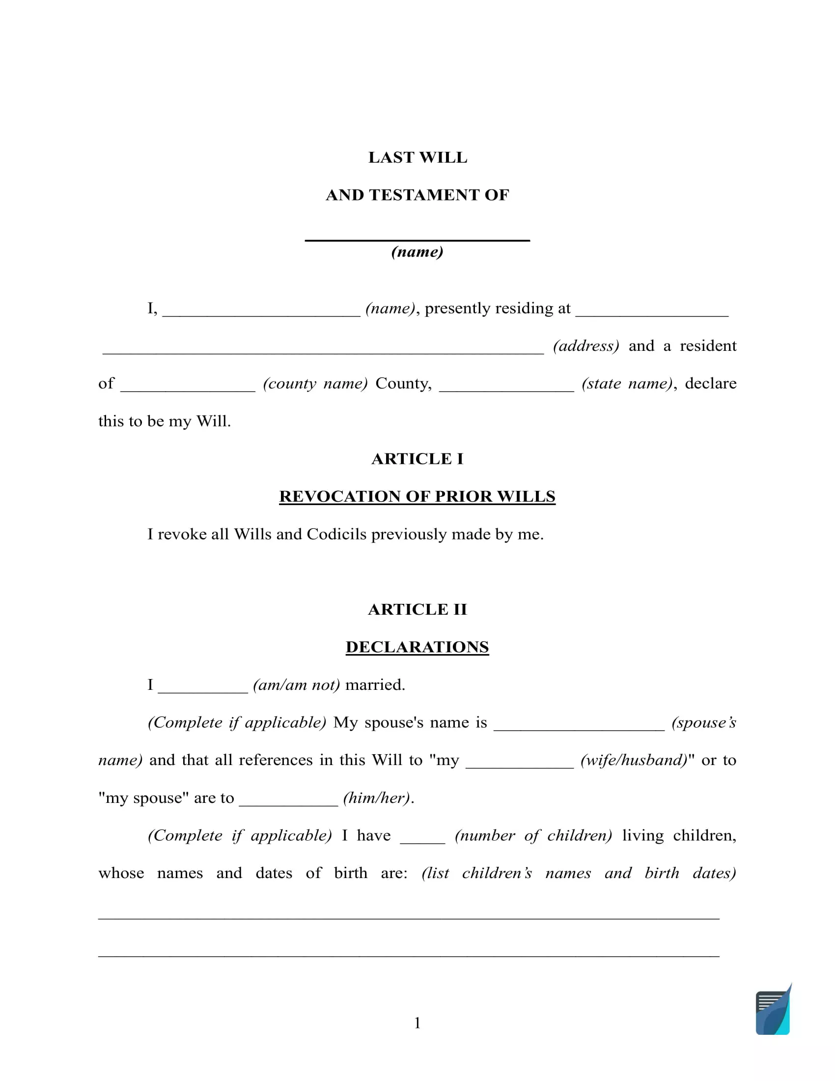
Sample Will Template
Here’s a sample last will template to give you a better understanding of how the final document is going to look like:
Living Will
If you’re looking for a valid living will template, we’ve got you covered too. A living will form is a special legal document that outlines an individual’s wishes regarding medical treatments that may prolong or save their life. Our living wills are created to fit the legal requirements in your state.
Popular State Living Will Forms
Unlike a last will, a living will addresses not your assets or property but your health. The document determines an individual’s (principal’s) preferences related to health care decisions if he or she becomes terminally ill or incapacitated. Your family and physicians will know for sure what end-of-life care you would like to receive with a living will form. The document provides essential details regarding life-sustaining treatments and circumstances they should or should not be used. So, you have to be very careful when creating one. The following state forms are widely used in the U.S. Check their requirements and terms if you live in one of these states.
If you live in Florida, you are recommended to use a Living Will Form Florida. It’s usually supported by a medical power of attorney, allowing you to appoint a health care surrogate to act as your representative. Together, these documents constitute an advanced health care directive. A Florida living will is a binding legal document and requires to be signed in the presence of two witnesses. A Florida living may lose its force if the principal becomes pregnant.
Apart from basic elements, an Ohio Living Will may include additional information about anatomical gifts and organ donation. If you want to become an organ donor, you should also complete a State of Ohio Living Will Declaration Notice. An Ohio living will may also be supported by a medical power of attorney. In any case, the documents have to be signed in the presence of two witnesses or a notary public.
To properly communicate your wishes regarding end-of-life care in Texas, you need to prepare a Living Will Form Texas, also known as Directive to Physicians and Family or Surrogates. This directive defines life-prolonging treatments and medical decisions if the principal cannot take care of themselves due to incapacity or terminal illness. A Texas living will must be signed in the presence of two witnesses, and a notary public presence is optional.
In Maryland, if you want to provide your family and physician with instructions for end-of-life care, you will need a Living Will Form Maryland, also called a Maryland Advanced Health Care Directive. You are free to customize this document as long as it perfectly fits your needs. You can include a health care agent or strike out this section if you do not need to appoint one. When the document is ready, you will have to sign it in the presence of two witnesses.
A Living Will New York allows a New York resident to specify every medical decision their physician can make if that person is incapacitated or has a severe illness. The document outlines life-sustaining and pain-relief instructions, but it’s also possible to include anatomical donation provisions. If you live in New York, you may choose to prepare an advanced directive and appoint your health care representative as well.
Living Will Forms by State
Depending on the state, a living will be called an advanced health care directive. Some states treat them as the same documents providing the individual’s wishes related to end-of-life care and life-sustaining treatments. However, in many states, an advanced health care directive is a more comprehensive document and includes a medical power of attorney. A medical POA allows you to appoint a trusted person to handle health care decisions on your behalf. You need to consult the state laws to decide which legal document is better to prepare. Below you will find the list of specific state living will forms.
- Alabama Living Will
- Arizona Living Will
- California Living Will Form
- Living Will Form Colorado
- Georgia Living Will Form
- Illinois Living Will
- Indiana Living Will
- Kentucky Living Will
- Living Will ME
- Living Will Form Michigan
- Missouri Living Will Form
- Living Will Form NJ
- NC Living Will
- Oklahoma Living Will
- Pennsylvania Living Will Form
- SC Living Will
- TN Living Will
- Living Will Virginia
- Living Will Form Washington State
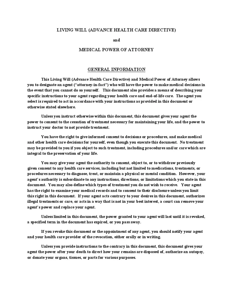
Sample Living Will
Power of Attorney
A power of attorney is a legal document that describes the relationships between two parties, the principal and the agent, or, as it is commonly referred to, the attorney-in-fact. When signed, this document transfers the ability to represent the principal in decision-making to the attorney-in-fact. Get the latest PoA forms by using one of the provided links below
The Most Widely Used Power of Attorney Forms
A power of attorney is a written authorization for one person, known as the agent or proxy, to act on behalf of another person, known as the principal. This document gives the agent authority to represent the principal in various circumstances. Depending on its type, a power of attorney may provide limited powers or grant the general authority. In any case, you need to appoint a trusted person who will not benefit from the provisions. Below you will find the most widely used power of attorney forms.
In order to grant your agent the authority to make medical decisions, you are expected to use a Medical Power of Attorney Template. This document is also considered durable and aims at securing your health matters in the unfortunate event of severe illness or incapacity. You can provide your agent with an extended authority to act on your behalf, including withdrawing artificial life-sustaining treatments, or you may list only several powers.
If you are a California resident looking for a medical POA, you are recommended to take advantage of a California Medical Power of Attorney. A California medical power of attorney has specific requirements regarding the agent appointment. In California, you cannot appoint your supervising health care provider or any employee of the medical institution where you are receiving treatments as your health care proxy.
In case you need a general POA in California, you can use a Power of Attorney California. A California power of attorney must be created by a person of legal age and sound mind. The document can give your agent a wide variety of powers to execute, but you are free to list only several of them. Apart from the principal, a California POA must be signed by two witnesses or a notary.
If you live in the state of Texas, you should create a Texas Power of Attorney. It will help you arrange your financial activities, for example, signing documents or paying bills, when you are absent or cannot do it yourself for other reasons. If you are not sure what powers to include in a Texas POA, you should consult an attorney who will help you understand the powers you are giving to the agent.
Sometimes, you need to appoint a person to act on your behalf only in a specific case or for a limited period of time. That’s when you need to create a Limited Power of Attorney. This form allows you to list your agent’s functions and not grant them full authority. You can also specify a period of time your power of attorney will be effective.
State Power of Attorney Forms by Type
Powers of attorney serve as solid legal instruments managing financial activities or health care decisions when a person cannot handle them on their own. A POA becomes invalid if the principal is incapacitated (if it’s not a durable POA) or dies. At the same time, a POA can have an ending date or be revoked anytime. It can be challenging to find a suitable state POA form, not to mention appropriate types. That’s why we’ve gathered essential state POAs by types, a list of which you will find below.
- AZ Durable Power of Attorney
- Medical Power of Attorney AZ
- California Durable Power of Attorney
- Colorado Durable Power of Attorney
- Colorado Medical Power of Attorney
- Florida Durable Power of Attorney
- Medical Power of Attorney Florida
- Durable Power of Attorney Georgia
- Medical Power of Attorney Georgia
- Medical Power of Attorney Idaho
- Illinois Durable Power of Attorney
- Illinois Power of Attorney for Health Care
- Indiana Durable Power of Attorney
- Indiana Health Care Power of Attorney
- Kansas Durable Power of Attorney
- Maine Health Care Advance Directive Form
- Durable Power of Attorney Maryland
- Medical Power of Attorney Maryland
- Massachusetts Durable Power of Attorney Form
- Massachusetts Health Care Proxy Form
- Michigan Durable Power of Attorney
- Michigan Medical Power of Attorney
- Medical Power of Attorney MN
- Missouri Durable Power of Attorney
- Missouri Medical Power of Attorney
- Durable Power of Attorney NJ
- Health Care Proxy NJ
- New York Durable Power of Attorney
- New York Health Care Proxy Form
- NC Durable Power of Attorney
- Medical Power of Attorney NC
- Durable Power of Attorney Form Ohio
- Ohio Medical Power of Attorney
- Oklahoma Durable Power of Attorney
- Oregon Durable Power of Attorney
- Health Care Power of Attorney Oregon
- Pennsylvania Durable Power of Attorney
- Health Care Proxy PA
- Durable Power of Attorney SC
- Health Care Power of Attorney SC
- Tennessee Durable Power of Attorney
- TX Durable Power of Attorney
- Texas Medical Power of Attorney
- Medical Power of Attorney Utah
- Virginia Durable Power of Attorney
- Virginia Health Care Power of Attorney
- Durable Power of Attorney Form Washington State
- Power of Attorney for Health Care WI
Power of Attorney Forms by State
The structure of powers of attorney is more or less the same. You need to include information about yourself, your agent, alternate agent (if any), governing law, and execution date. But you have to remember that signing requirements can vary from state to state. Usually, you need two witnesses or a notary public. That’s why it’s crucial to check the local laws and choose a POA form specific to your state. You can check the forms below if you need a state POA form.
- Alabama Power of Attorney
- Alaska Power of Attorney
- Arizona Power of Attorney
- Arkansas Power of Attorney
- Power of Attorney Form Colorado
- Power of Attorney Form CT
- Power of Attorney Delaware
- Power of Attorney Florida
- Power of Attorney GA
- Hawaii Power of Attorney
- Idaho Power of Attorney
- Illinois Power of Attorney
- Power of Attorney Form Indiana
- Iowa Power of Attorney Form
- Kansas Power of Attorney
- Power of Attorney Kentucky
- Louisiana Power of Attorney
- Maine Power of Attorney
- Power of Attorney Forms Maryland
- Massachusetts Power of Attorney
- Power of Attorney Form Michigan
- MN Power of Attorney Forms
- Power of Attorney Mississippi
- Power of Attorney Form Missouri
- Power of Attorney Form Montana
- Power of Attorney Form Nebraska
- Power of Attorney Form Nevada
- New Hampshire Power of Attorney
- NJ Power of Attorney Forms
- NM Power of Attorney
- Power of Attorney Form New York
- North Carolina Power of Attorney
- Power of Attorney Form ND
- Ohio Power of Attorney Form
- Power of Attorney Form Oklahoma
- Oregon Power of Attorney
- Pennsylvania Power of Attorney Forms
- Rhode Island Power of Attorney
- SC Power of Attorney
- South Dakota Power of Attorney
- Power of Attorney Form for Tennessee
- Utah Power of Attorney Form
- Vermont Power of Attorney
- Power of Attorney Virginia
- Washington State Power of Attorney
- Power of Attorney Form WV
- Wisconsin Power of Attorney
- Wyoming Power of Attorney
Power of Attorney Types
Depending on the circumstances, you may need to prepare different powers of attorney. The main four POA types include general power of attorney, limited power of attorney, durable power of attorney, and springing power of attorney. We’ve mentioned durable and limited POAs above. Unlike a durable POA, a springing POA is a document that comes into force only if the principal becomes incapacitated. That’s why medical POAs are often made springing. A general POA, in its turn, is a comprehensive document containing an extensive list of powers granted to the agent. No matter what POA type you need, you should always choose a reliable person as your agent.
- Power of Attorney Template for Children
- General Power of Attorney
- Power of Attorney IRS
- Vehicle Power of Attorney
- Power of Attorney for Real Estate
- Revocation of Power of Attorney
- Power of Attorney for Tax
Sample PoA:

Small Estate Affidavit
Another document you might want to have ready when working on estate planning and estate distribution is a small estate affidavit. Browse the small estate affidavit forms that we have prepared for you below.
Popular State Small Estate Affidavit Forms
A small estate affidavit allows a legal heir to claim the inheritance rights. This affidavit helps expedite a probate process but can only be used for an estate that is lower than a certain amount. This amount depends on the state and ranges from $5000 to $100000. Sometimes, you need to attach a death certificate of the person who left the inheritance (the decedent). To prepare a small estate affidavit properly, you need to consult your local requirements. The following small estate affidavit forms are more in demand than others. Check their requirements if you a resident of one of these states.
If you live in California, you may face some additional considerations when preparing a California Small Estate Affidavit. In California, you are required to attach a death certificate to your small estate affidavit form. The document should be filed only 40 days after a person’s death and signed in the presence of an attorney. The maximum amount of the estate can reach up to around $170000. There are also some additional forms you will have to fill out.
In Illinois, you may use an Illinois Small Estate Affidavit to claim the inheritance rights to personal property. The maximum value of the property should not exceed $100000. An Illinois small estate affidavit cannot include the real property. To fill out this form, you will also need to list the decedent’s debts and unpaid bills.
If a person dies without a will in Texas, their heirs can prepare a Texas Small Estate Affidavit. To file a small affidavit in Texas, it’s necessary to wait 30 days from the date of the person’s death. The maximum amount of the estate should not exceed $75000. A Texas small estate affidavit should be approved by the probate court in the county where the person dies.
Small Estate Affidavit Forms by State
Every small estate affidavit form includes the contacts of a legal heir, their relationship to the decedent, the decedent’s details, description of their property and assets, how it should be divided among heirs, debts, and funeral expenses. However, your state laws can influence the preparation process in terms of waiting periods, signing requirements, and additional documents to be attached. We’ve prepared a list of all necessary state small affidavit forms below as a matter of convenience.
- Alabama Small Estate Affidavit Form
- Arizona Small Estate Affidavit
- Arkansas Small Estate Affidavit
- Colorado Small Estate Affidavit
- Florida Small Estate Affidavit Form
- Small Estate Affidavit Georgia
- Small Estate Affidavit Idaho
- Small Estate Affidavit Form
- Iowa Small Estate Affidavit
- Small Estate Affidavit Kansas
- Small Estate Affidavit Louisiana
- Maryland Small Estate Affidavit
- Massachusetts Small Estate Affidavit
- Michigan Small Estate Affidavit
- Minnesota Small Estate Affidavit
- Small Estate Affidavit Mississippi
- Small Estate Affidavit MO
- Nebraska Small Estate Affidavit
- Small Estate Affidavit Nevada
- NJ Small Estate Affidavit
- Small Estate Affidavit New Mexico
- Small Estates Affidavit NY
- North Carolina Small Estate Affidavit
- Ohio Small Estate Affidavit
- Oklahoma Small Estate Affidavit
- Oregon Small Estate Affidavit
- Small Estate Affidavit Pennsylvania
- South Carolina Small Estate Affidavit
- Tennessee Small Estate Affidavit
- Small Estate Affidavit Utah
- Small Estate Affidavit Virginia
- Washington State Small Estate Affidavit
- Wisconsin Small Estate Affidavit
Lease Agreement Templates
There are countless potential issues with an unprofessional rental agreement, ranging from the inability to evict tenants to huge repair costs or other property damages that otherwise would’ve been avoided. A proper lease agreement and real estate contract are created to ensure that every party understands their rights and responsibilities. Below is the complete list of rental agreement forms and templates that we have put together for your convenience.
The Most Widely Used Lease Agreement Templates
A lease agreement is the basis of successful relationships between landlords and tenants. The agreement usually outlines in detail all tenancy terms and policies. A landlord and tenant should check and recheck their lease agreement and ensure they clearly understand each other. Depending on the renting premises, there are various lease agreement types. The most popular ones are a one-page rental agreement, sublease agreement, rent-to-own agreement, room rental agreement, commercial lease, and roommate agreement. We will look closely at them in the following sections.
Before signing a lease agreement, a landlord wants to learn more about their potential tenants with the help of the Rent Lease Application Form. Along with this form, they can request a tenant to consent to the credit history or background check. It allows landlords to choose their tenants more carefully. Tenants may also take advantage of a rental application form and put their best side forward.
When a landlord finds their perfect tenant, they can sign a Simple Rental Agreement. A simple one-page rental agreement is used only for residential property and includes basic information related to the tenancy such as length of the lease, rent amount, security deposit, and notice requirements. Still, it’s an efficient way to manage landlord-tenant relationships since the agreement provides all the details for a tenant to fulfill their contractual obligations.
If you would like to rent out your property in California, you will have to provide a list of disclosures to your tenant along with signing a California Rental Agreement. They include the lead-based paint disclosure, bedbug addendum, flood disclosure, pest control, mold disclosure, and smoking policy disclosure.
A tenant can rent out the landlord’s premises using a Sublease Agreement Template. It’s concluded between a tenant, also referred to as a sublessor, and subtenant and must be approved by a landlord. This agreement is considered to be the lease within the lease, and the tenant must still comply with the original rental agreement. A sublease agreement comes in handy when the tenant cannot continue to live on the premises and finds another person to rent the property until the original lease expires.
If you want to buy residential property but cannot afford it yet, a good way out is a Lease to Own Agreement. This document is technically a lease agreement but with the option to buy the property at the end of the lease term. That’s why it must include earnest money deposit, purchase price, and how much rent go towards the purchase, apart from standard lease agreement terms and policies.
A Room Rental Agreement Template allows a homeowner or original tenant to rent out or sublet a room. It’s an option for a landlord who wants to lease the rooms in the apartment separately. This document contains all the same terms and provisions that a standard lease agreement would.
Unlike a room rental agreement, a Roommate Agreement Template is concluded between tenants living on the same rental premises. In this case, a landlord is not involved, and tenants use this agreement to manage their financial obligations and household rules. A roommate agreement is considered legally binding, so the tenants should take this document seriously.
In order to rent out a business property, it’s necessary to use a Commercial Lease Agreement Template. Commercial property means property that is not used for residential purposes, for example, offices, restaurants, or warehouses. Usually, the rent for commercial property is calculated as a cost per square foot. A commercial lease agreement lasts longer than a residential one.
A landlord or tenant may decide to end the tenancy earlier than it expires. They are expected to use a Termination of Lease Letter to notify each other of such a decision. A landlord is not obliged to renew the lease but has to provide the tenant with a notice to vacate. The same implies to the tenant – they have to send an intent to vacate. As a rule, a lease agreement should provide notice requirements the landlord or tenant must comply with when deciding to terminate the tenancy early. Here’s a sample to give you a better idea:

State Lease Agreement Templates by Type
A lease agreement is concluded between a landlord and tenant if the latter’s rental application is approved. If you are looking for a specific type of lease agreement or related application forms, check the list below. The documents are divided by both type and state for your convenience.
- California Rental Application
- California Commercial Lease
- California Month to Month Rental Agreement
- California Rent Increase Form
- Room Lease Agreement California
- California Sublease Agreement Template
- Florida Rental Application
- Florida Commercial Lease Form
- Florida Month to Month Lease
- Massachusetts Rental Application
- Greater Boston Real Estate Board Lease
- Rental Application NY
- Sublease Agreement New York
- NC Rental Application
- Texas Rental Application Form
- Texas Commercial Lease Form
- Wisconsin Rental Application
Lease Agreement Templates by State
Lease agreements outline the responsibilities and obligations of a landlord and tenant. State laws require a lease agreement to be in writing and signed by both parties. Some lease terms may vary from state to state, for example, a security deposit amount. Many states have statutory limits on how much money landlords can request as a deposit. These limits usually depend on the rent amount. The following lease agreement templates are prepared considering all essential state requirements.
- Rental Agreement Alabama
- Arizona Rental Agreement
- Rental Agreement Colorado
- Rental Lease Agreement CT
- Florida Lease Agreement
- Rental Agreement Georgia
- Hawaii Lease Agreement
- Lease Agreement Illinois
- Chicago Apartment Lease Form
- Indiana Rental Agreement
- Louisiana Rental Agreement
- Maryland Rental Agreement
- Massachusetts Lease Agreement
- Rental Agreement Michigan
- Rental Agreement MN
- Missouri Residential Lease Agreement
- Nevada Rental Agreement
- Lease Agreement NJ
- New Mexico Rental Agreement
- New York Residential Lease Agreement
- Lease Agreement NC
- Ohio Residential Lease Agreement
- Oklahoma Rental Agreement
- Oregon Lease Agreement
- Rental Agreement PA
- SC Lease Agreement
- Tennessee Rental Agreement
- Lease Agreement Texas
- Utah Lease Agreement
- Rental Lease Agreement Virginia
- Rent Agreement WA
- Wisconsin Residential Lease Agreement
Lease Agreement Types
Renting property requires an accurate lease agreement. Depending on the property type, you will have to prepare a specific agreement. For example, if you would like to rent out your property regularly, you should create a week-to-week or month-to-month rental agreement. If you need space where you could leave your car, consider creating a parking rental agreement. The following lease templates will be helpful for both landlords and tenants.
- Garage Lease Agreement
- Photo Booth Contract
- Salon Booth Rental Agreement
- Commercial Sublease Form
- Venue Contract Template
- Wedding Venue Contract Template
- Condominium Lease Agreements
- Family Rental Agreement
- Hunting Lease Contract
- Month to Month Lease Agreement
- Parking Space Rental Agreement
- Roommate Agreement Dorm
- Short Term Lease Agreement
- Week to Week Rental Agreement
Termination Letter Templates
If you are wondering how to terminate your tenancy earlier than expected, the list below is for you. State laws allow early lease termination if a landlord or tenant notify each other in advance. The notice periods vary from state to state and range from 20 to 60 days. But notice periods and requirements can also be provided directly in the lease agreement.
- Early Termination of Lease Letter
- Arizona 30 Day Eviction Notice
- California 30 Day Notice to Vacate
- 60 Day Notice to Vacate California
- Florida Lease Termination
- 30 Day Notice to Vacate Illinois
- 30 Day Notice of Termination NYC
- Ohio Notice to Vacate
- 30 Day Notice to Vacate Oregon Template
- 30 Day Notice to Vacate Texas Template
- Notice to Vacate Washington State
Other Templates Related to Lease Agreements
The following forms can come in handy if a landlord needs to renew the lease or notify a tenant about a rent increase. In some cases, a landlord has to give a written consent to approve a sublease agreement their tenants will sign. All these situations require specific forms and letters to be filled out, which you will find below.
Eviction Notices
A violation of the lease agreement terms can lead to eviction. Eviction means that a tenant will be removed from the renting premises if they do not fix the problem. However, eviction is not a quick process, and it can take some time before a landlord obtains a writ of possession. To start the process, the landlord should send an eviction notice, also known as a notice to quit, and give the tenant the possibility to cure the situation.
The Most Widely Used Eviction Notices
When sending an eviction notice, a landlord must consider the violation nature, state laws, and agreement’s terms. The notice usually includes the description of the violation, the way to cure it, and the number of days to fix the problem. These notices are called “curable.” But there is also an incurable type of eviction notices, which gives the tenant no other option but to move out.
One of the most frequent notices to quit is a Late Rent Notice Template sent following late rent payment. In this case, the landlord informs the tenant about the amount due to pay, late fees (if any), and the deadline for paying it or leaving. The notice period is usually three to five days. If the tenant ignores the note, the landlord may start the eviction process by addressing the court.
As a rule, a 3 Day Notice to Quit is used to notify the tenant about nonpayment of rent. However, depending on the state, it can also inform about non-monetary default. As the name implies, a 3-day notice to quit gives the tenant only three days to cure the situation or leave the property.
A 60 Day Eviction Notice, in its turn, is sent when the landlord wants to end a month-to-month tenancy. It’s possible to do if the tenant possesses the property for longer than one year. A 60-day notice is considered the most amicable one, as it gives the tenant enough time to find another place to live. But this notice can also be required by state laws.
Such requirements exist in California. The landlord has to send a California Eviction Notice 60 days in advance if they want to terminate a month-to-month lease with the tenant who lives on the premises for a year or more. Otherwise, the landlord can send a 30-day California Lease Termination Letter. For nonpayment of rent or noncompliance with the agreement, the landlord should send a 3-day notice to quit.
In Texas, you can use a Notice to Vacate Texas Form to inform the tenant about possible eviction. Late rent or noncompliance with the agreement requires a 3-day notice, while a lease termination notice is sent 30 days in advance. Texas law allows the landlord to give a 2-day grace period for paying the rent after the due date.
Eviction Notice Types
Eviction notices are divided into types regarding the given time period. These periods usually depend on the violation nature and local requirements. Additionally, these terms can be explicitly provided in the agreement between a landlord and tenant. Note that these terms cannot conflict with the law. For example, if a notice period required by the state is 60 days, the landlord should not provide only 20 days.
- 10 Day Notice to Vacate
- 14 Day Eviction Notice
- 5 Day Notice to Vacate Form
- 7 Day Notice to Quit
- Notice of Noncompliance
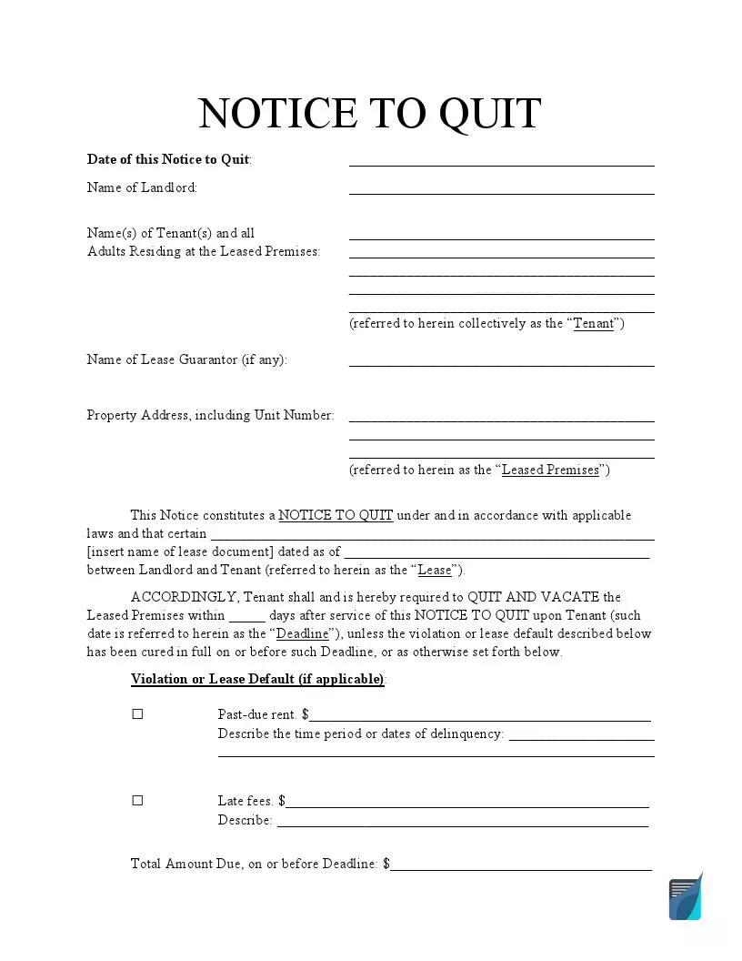
Sample Notice to Quit:
Eviction Notices by State
Some states provide landlords with more powers related to eviction. For example, in New Jersey, you can end the tenancy without notice in the case of late rent payments. In some cases, you can send unconditional quit notices that do not allow the tenant to fix the situation. They are applied for severe or repeated violations, such as illegal activities on the premises (distributing drugs, engaging in prostitution or related activities, or using and possessing a firearm without legal permission).
- Alabama Eviction Notice
- Notice to Vacate AZ
- Arkansas Eviction Notice Form
- Colorado Notice to Vacate
- Eviction Notice CT
- Eviction Notice Template Florida
- GA Eviction Notice Form
- Illinois Eviction Notice Form
- Indiana Notice to Quit
- Kansas Notice to Vacate
- Louisiana Eviction Notice
- Maryland Notice to Vacate
- Massachusetts Notice to Quit
- Michigan Notice to Quit
- Minnesota Eviction Notice Form
- Notice to Vacate Missouri
- NJ Notice To Quit
- Eviction Notice Template NY
- NC Eviction Notice Template
- Ohio Eviction Notice Form
- Oklahoma Eviction Notice
- Oregon Eviction Notice Form
- PA Notice to Quit
- SC Eviction Notice Template
- Eviction Notice Tennessee
- Utah Eviction Notice
- Eviction Notice in VA
- Notice to Vacate Washington State
- WV Eviction Notice
- Wisconsin Eviction Notice
State Eviction Notices by Type
If you need a specific state eviction notice form, the following list is for you. These forms are prepared considering state requirements. For example, the landlord needs to send a 3-day notice in California or Florida if the tenant misses a rent payment. Still, in Michigan, you must notify the tenant seven days in advance.
- 3 Day Notice California
- 3 Day Eviction Notice Florida Template
- 30 Day Eviction Notice Florida
- 5 Day Notice Illinois
- Michigan 7 Day Notice
- NYS 3 Day Eviction Notice
- 3 Day Eviction Notice Ohio
- 72 Hour Notice Oregon
- 3 Day Eviction Notice Texas
- 5 Day Notice Wisconsin
Release Of Liability Templates
A release of liability is a legal document that protects an individual or entity from legal responsibilities. With this document, one party, the releasor, promises not to sue another party, the release. This promise may be related to the physical risk and extreme activities, as well as a car accident. A release of liability can also be used to document a person’s consent to be recorded.
The Most Widely Used Release of Liability Forms
A release of liability can protect the business from possible lawsuits. The document should always include the releasor’s and releasee’s contact information, the event or activity, consideration (if any), effective date, and governing law. The following documents are the most widely used release of liability forms related to future and past events.
One of the most popular releases is a Medical Release Form. The federal Health Insurance Portability and Accountability Act of 1996 (HIPAA) forbids health providers from disclosing a patient’s information without valid authorization. A medical release form gives such authorization and includes the list of individuals, such as family members, friends, or other parties who will have access to a person’s medical records.
A Photo Release Form Template will help you confirm a person’s consent to be photographed or use their photos for personal or commercial purposes. The form ensures that the person is aware of being photographed and agrees to the usage of their images.
A similar to the previous one is a Standard Model Release Form. It aims at getting a model’s consent to pose in pictures. The document is concluded between an artist and a model and is widely used in stock photography, commercials, or clothing modeling.
Another release form related to the entertainment sphere is a Film Release Form Template. It allows an individual or entity to use someone’s likeness recorded in video and photographed. This form can be used for personal or commercial usage. Signing the film release, a person allows a third party to use their likeness and voice.
As mentioned before, a release of liability can be used for past events, for example, a Car Accident Release of Liability Form. The document helps avoid legal responsibility in the event of a car accident. The injured party may agree to sign the release in exchange for compensation and release the liable party from being sued.
Release of Liability Types
If you need to prepare a specific release of liability form, check the list below and choose the one that suits your needs. When creating the document, do not forget to include a description of the event or activity, risks and danger provisions, compensation provisions (if any), effective date, and governing laws.
- Art Release Form
- Release of Liability Form Car
- Interview Release Form Template
- Film Location Release Form
- Conditional Lien Release Form
- Partial Release of Lien
- Unconditional Lien Release
- Media Release Form Template
- Dental HIPAA Release Form
- Mortgage Lien Release Form
- Music Release Form for Film
- Personal Training Waiver and Release Form
- Photography Copyright Release
- Permission to Photograph Form for Daycare
- Employee Photo Consent Form
- Photo Release Form for Minors
- Pet Photo Release Form
- Form SSA 3288
- Talent Release Form Template
- Actor Release Form Template
- Tattoo Waiver Form
- Doctor Release Form
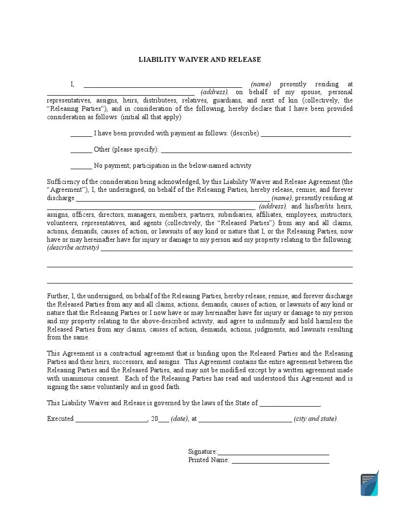
Sample Release of Liability:
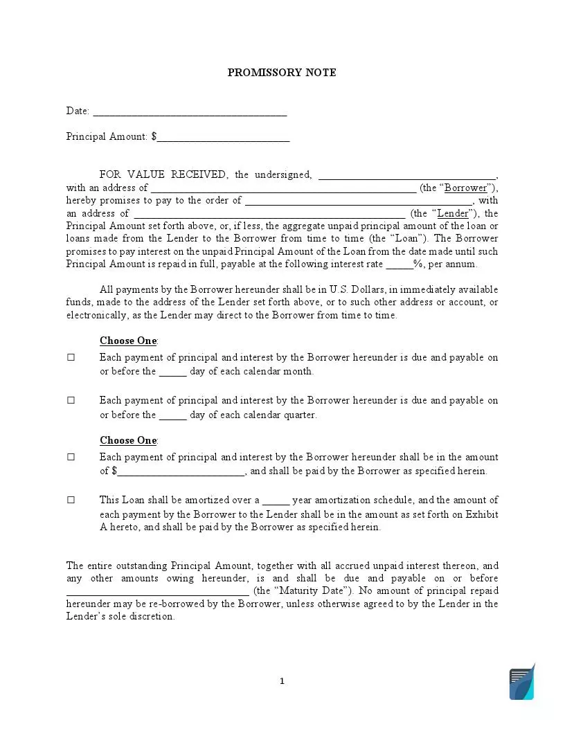
Fillable Promissory Notes
A promissory note is a legal and financial instrument that enforces an individual or entity to repay the borrowed money. A promissory note is often referred to as a loan agreement or IOU but there are slight differences between them. The note can be used in many circumstances, including mortgage, student loans, and business loans. If you want to get a high-quality promissory note, check the forms below and choose the appropriate type.
Popular Promissory Note Forms
A lender is always recommended to use a Secured Promissory Note Template. This note provides collateral security in the form of a car or house. Thus, if the borrower does not repay the money, the lender will get these assets. A secured promissory note offers stronger security for the lender and, as a rule, allows the borrower to pay a lesser interest rate.
If the lender relies on the borrower’s credibility, they can use an Unsecured Promissory Note Template to prepare the document. An unsecured promissory note provides no guarantee for the lender to get the borrowed money back and offers no remedy against failure to pay. If the borrower fails to pay back, the lender will have to file a lawsuit to recover the loan.
If you live in California, you can take advantage of a Promissory Note Template California to create your secure or non-secure promissory note. Like in all states, California promissory notes are governed by the state’s usury laws. In California, it’s possible to charge the maximum interest rate of 10% for family, personal, or household purposes.
Promissory Note Forms by State
A promissory note outlines all the terms and conditions of the loan. The document includes the lender’s and borrower’s contact details, the amount of money being borrowed, the collateral type, repayment schedule, and the interest rate. The annual interest rate may vary from state to state. Each state has its usury laws limiting the interest rate a lender can charge. For example, in California, it’s 10%, but you can only charge up to 7% in Michigan. As the lender, you will need to check the local requirements and select one of the state forms to create an accurate promissory note.
- AL Promissory Note Form
- Promissory Note Arizona
- Colorado Promissory Note
- Connecticut Promissory Note
- Promissory Note Template Florida
- Georgia Promissory Note
- Illinois Promissory Note
- Promissory Note Indiana
- Promissory Note IA
- KS Promissory Note
- Kentucky Promissory Note Template
- Louisiana Promissory Note
- Promissory Note MD
- Massachusetts Promissory Note
- Promissory Note Michigan
- Promissory Note MN
- Missouri Promissory Note
- Promissory Note NV
- NJ Promissory Note
- Promissory Note Template New York
- Promissory Note NC
- Ohio Promissory Note
- Promissory Note Oregon
- Promissory Note SC
- Promissory Note Template Texas
- Utah Promissory Note
- Virginia Promissory Note
- Promissory Note Template Washington State
- Wisconsin Promissory Note
Promissory Note Types
Apart from secured and unsecured promissory notes, there are also a vehicle promissory note and promissory note release. A vehicle promissory note is a binding document that ensures a buyer of the vehicle will pay the purchase price in accordance with the note terms. A promissory note release, in its turn, releases the borrower from all responsibilities and obligations related to the note. This document is usually given when the promissory note terms are entirely fulfilled.
Sample Promissory Note:
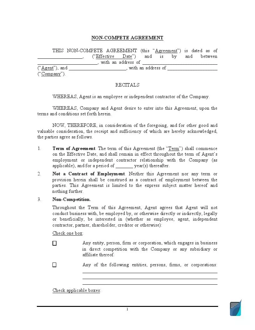
Find Fillable Non-Compete Agreement
A non-compete agreement prevents one party from competing with another party in a specific industry and geographical area. This document is the most common practice when hiring new employees. A non-compete agreement (get our updated NCA here) can serve as additional protection for your business but should have reasonable terms. “Reasonable” means that the agreement duration should not exceed a certain period of time (usually, two years maximum) and should cover only the relevant geographical area.
Popular State Non-Compete Agreement Forms
When it comes to non-compete clauses or non-compete agreements, state laws are not the same. In many states, these agreements are considered void, while in others, you have to comply with strict requirements when creating such an agreement.
A Non Compete Agreement California Template can help you restrict your employees from working for competitors for a certain period or creating a similar business in the same area. But in California, non-compete agreements are generally considered unenforceable. If you want to create a California non-compete agreement, it’s necessary to obtain legal advice.
In Florida, non-compete agreements are allowed to be used by employers as long as they provide reasonable terms. A Non Compete Agreement Florida Template will help you create a valid legal document to protect your company’s sensitive information and intellectual property rights. To be considered reasonable, your Florida non-compete agreement should not last for more than six months.
A Texas Non Compete Agreement is a legally binding document protecting your legitimate business interests. In Texas, non-compete agreements usually provide certain compensation for the employee who agrees to sign the agreement. It comes in the form of a pay raise or promotion. A Texas non-compete agreement is considered reasonable if the agreement’s duration does not exceed two years.
Non-Compete Agreements by State
As mentioned above, a non-compete agreement is a matter of state jurisdiction, so you have to be careful when preparing one. Such agreements cannot be legally binding in North Dakota and Oklahoma. California does not recognize them as well. Many states require non-compete agreements to be reasonable in terms of time limits and geographic scope. The following list of state non-compete forms will help you save time searching all the local requirements.
- Alabama Non Compete Agreement
- Alaska Non Compete Agreement
- Non Compete Arizona
- Arkansas Non Compete Agreement
- Non Compete Agreement Colorado
- Connecticut Non Compete
- Delaware Non Compete Agreement
- Georgia Non Compete
- Non Compete Agreement HI
- Idaho Non Compete
- Non-Compete Agreement Illinois
- Non Compete Indiana
- Iowa Non Compete Agreement
- Kansas Non Compete Agreement
- Kentucky Non Compete
- Louisiana Non Compete
- Non Compete Agreement ME
- Non Compete Maryland
- Non Compete Agreement Massachusetts Template
- Non Compete Michigan
- Non Compete Agreement Minnesota
- Non-Compete Mississippi
- Non Compete Agreement Missouri Template
- Non Compete Agreement Montana
- Non Compete Agreement NE
- Non Compete Nevada
- New Hampshire Non Compete Agreement
- Non Compete Agreement New Jersey
- New Mexico Non Compete Agreement
- Non-Compete Agreement New York Template
- North Dakota Non Compete Agreement
- Ohio Non Compete
- Oklahoma Non Compete Agreement
- Non Compete Oregon
- Non Compete Agreement Pennsylvania
- Non Compete RI
- South Carolina Non Compete
- SD Non Compete Agreements
- Non Compete Tennessee
- Non Compete Agreement Utah
- Vermont Non-Compete Agreement
- Virginia Non Compete Agreement
- Non Compete Agreement Washington
- Non Compete Agreement WV
- Non Compete Wisconsin
- WY Non Compete Agreement
Non-Compete Agreement Types
The primary purpose of a non-compete agreement is to ensure that your employees will not engage in competition that may harm your company and influence its share in the market. It relates to both permanent employees and independent contractors who may access highly sensitive and valuable information during their work. That’s why the following templates can be helpful to protect your company’s interests.
Sample Non-Compete Agreement:
Fillable Prenuptial Agreement
Prenuptial agreements, also known as antenuptial agreements or prenups, outline what will happen to financial assets and debts if the couple decides to divorce. It can come in handy in distinguishing what separate and community property is after the marriage, as well as defining child support and alimony. A prenuptial agreement shows the partners’ serious intention to be together, so it’s worth considering one before getting married.
Popular Prenuptial Agreement Forms
A prenuptial agreement aims at protecting both parties in the event of divorce. That’s why it’s crucial to thoroughly check all the provisions before signing the agreement to avoid being mistreated. Although prenups are legally enforceable documents, the court may still set aside or change some provisions. It’s particularly true to child custody and the amount of child support.
Florida is not a community property state, which means that the marital property and assets will be divided equitably between spouses (not equally). However, a Florida Prenuptial Agreement Form may still be a valuable legal instrument if you want a more active role in deciding marital property distribution in case of divorce or one spouse’s death. The agreement will secure your individual property or family assets, as well as the inheritance of children from a previous marriage(s).
Texas law also allows a couple to enter into a prenuptial agreement. The document includes the spouses’ rights and obligations regarding any property acquired during the marriage and its usage. If you live in Texas and want to be more in control of the marriage’s financial part, you are free to use a Texas Prenuptial Agreement and include there all the relevant provisions.
A California Prenuptial Agreement Form is designed for California residents who want to clarify what will happen to their property and finances after marriage dissolution. California is a community property state, which means that all marital property should be divided equally in the event of divorce. But a prenup will give a couple the possibility to decide on their own what should be divided 50/50 and what should remain separate property.
Prenuptial Agreement Forms by State
All 50 states allow romantic partners to conclude a prenuptial agreement. The majority of states use the Uniform Premarital Agreement Act (UPAA/UPMAA) to determine when and how prenups should be enforced. As a general rule, the agreement should be in writing and signed by both spouses. However, signing requirements may vary from state to state. For example, in New York or New Mexico, you have to notarize the prenup, while you need two witnesses to sign the agreement in Minnesota.
- Prenuptial Agreement AL
- Prenuptial Agreement AK
- Arizona Prenuptial Agreement
- Prenup Agreement in Arkansas
- Prenuptial Agreement Colorado
- Prenuptial Agreements in CT
- Prenup Agreement in Delaware
- Georgia Prenuptial Agreement Form
- Hawaii Prenuptial Agreement Form
- Idaho Prenuptial Agreement Form
- Illinois Prenuptial Agreement
- Prenuptial Agreement IN
- Prenuptial Agreement IA
- Prenuptial Agreement KS
- Prenuptial Agreement in Kentucky
- Prenuptial Agreement Louisiana
- Prenuptial Agreement Maine
- Maryland Prenuptial Agreement
- Prenuptial Agreement Massachusetts Sample
- Prenuptial Agreements in Michigan
- Prenuptial Agreement MN
- Prenuptial Agreement Mississippi
- Missouri Prenuptial Agreement Form
- Prenuptial Agreement in MT
- Nebraska Prenuptial Agreement
- Prenuptial Agreement NV
- Prenuptial Agreement NH
- NJ Prenuptial Agreements
- Prenuptial Agreement NM
- Prenup Agreements New York
- Prenup Agreement NC
- Prenuptial Agreement ND
- Ohio Prenuptial Agreement
- Oklahoma Prenuptial Agreement Form
- Prenuptial Agreement OR
- Pennsylvania Prenuptial Agreement
- Prenuptial Agreement RI
- Prenuptial Agreement SC
- Prenuptial Agreement SD
- Prenuptial Agreement TN
- Utah Prenuptial Agreement Forms
- VT Prenuptial Agreement
- Prenuptial Agreement Virginia
- Washington State Prenuptial Agreement Form
- Prenuptial Agreement WV
- Prenuptial Agreements in Wisconsin
- Prenuptial Agreement Wyoming
Find Fillable Operating Agreement
A limited liability company (LLC) operating agreement defines relations between company members and outlines their rights, obligations, and liabilities. Each operating agreement includes the company name and address, the formation details, its registered agent, ownership type, business purpose, and member capital contributions. Depending on the LLC type, the company may have only one LLC member or several founding members. You can create an operating agreement at any stage of your company’s existence, but it’s always better to do it at the beginning to manage all business decisions properly.
The Most Widely Used Operating Agreement Forms
Operating agreements set out the terms of LLCs under the specific owners’ needs. Companies that do not have operating agreements have to comply only with state laws and rules. However, these rules can be too general to control the LLC effectively. So, it’s worth creating one to protect and manage your business. There are two main types of LLC operating agreements – single-member and multi-member.
A Single Member Operating Agreement is designed for a company with only one founding member (owns 100% capital interest). The document helps establish the company’s status separately from the owner’s assets and protects these assets from the LLC’s debts and obligations. A single-member operating agreement is recommended to sign in the presence of a notary public since there is only one person who will sign the form.
If your LLC has more than one funding member, then you will need a Multi Member LLC Operating Agreement Template to create your document. This form is crucial for providing clear communication between all company members and avoiding potential misunderstandings or disputes. A multi-member LLC operating agreement is also recommended to be signed in the presence of a notary public with the copies distributed among all LLC members.
An operating agreement is not required in Florida, but you can use an LLC Operating Agreement Florida to define how your company will be managed. It will help you outline the LLC governing structure and all members’ responsibilities and expectations. Additionally, a FLorida LLC operating agreement will be useful in the event of legal disputes.
Having an operating agreement in California is required by state law. An Operating Agreement LLC California Template is designed to not only fulfill the state requirements but also to protect your LLC status. Although California law requires the LLC’s owner to have an operating agreement, it does not oblige them to file it. The form defines the LLC terms and rules and should be kept internally.
An LLC Operating Agreement Texas is a legal document to define procedures and rules of the LLC registered in Texas. It protects the personal assets and accounts of the LLC members from being financially liable in the event of legal disputes. A Texas LLC operating agreement is not required by law but serves to create a suitable LLC governing structure.
Operating Agreement Forms by State
As a rule, companies’ owners are not legally obliged to create operating agreements. Still, a few states may require you to have an LLC operating agreement. These states are California, Delaware, New York, Maine, and Missouri. Even if an operating agreement is not required in your state, it’s recommended to have one because it allows you to control your business as you wish. Check the forms below and choose the operating agreement template according to the state you live in.
- Alabama LLC Operating Agreement
- LLC Operating Agreement Alaska
- Arizona LLC Operating Agreement
- Operating Agreement LLC Arkansas
- Colorado LLC Operating Agreement
- Connecticut LLC Operating Agreement
- Delaware LLC Operating Agreement Template
- Georgia LLC Operating Agreement
- LLC Operating Agreement Hawaii
- Idaho LLC Operating Agreement
- Illinois LLC Operating Agreement
- Indiana LLC Operating Agreement
- Iowa Certificate Of Organization
- Operating Agreement LLC Kansas
- Kentucky LLC Operating Agreement
- Louisiana LLC Operating Agreement
- Operating Agreement LLC Maine
- Operating Agreement LLC Maryland
- MA LLC Operating Agreement
- LLC Operating Agreement Michigan
- LLC Operating Agreement Minnesota
- MS Llc Operating Agreement
- Operating Agreement for LLC Missouri
- LLC Operating Agreement Montana
- Certificate Of Organization Nebraska Template
- Operating Agreement LLC Nevada
- New Hampshire LLC Operating Agreement
- New Jersey LLC Operating Agreement
- NM LLC Operating Agreement
- New York LLC Operating Agreement
- North Carolina LLC Operating Agreement
- ND LLC Operating Agreement
- Operating Agreement LLC Ohio
- Oklahoma LLC Operating Agreement
- Oregon LLC Operating Agreement
- Pennsylvania LLC Operating Agreement
- RI LLC Operating Agreement
- SC LLC Operating Agreement
- SD Organizational Agreement LLC
- TN LLC Operating Agreement
- Operating Agreement LLC Utah
- VT LLC Operating Agreement
- Virginia LLC Operating Agreement
- Washington State LLC Operating Agreement
- WV LLC Operating Agreement
- Operating Agreement LLC Wisconsin
- Wyoming Operating Agreement
Sample Operating Agreement:
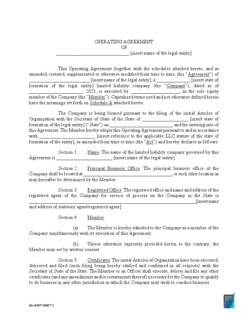
Find Fillable Marital Settlement Agreement
A marital settlement agreement is a written document outlining property and assets division after the divorce. It can also include provisions related to child custody and support and alimony arrangements. Such agreements help avoid a lengthy and exhausting divorce process and make things a lot easier for both spouses. If prepared correctly and covering all the essential aspects of the divorce, the agreement may be honored by the judge, and spouses will not have to go to court. In any case, a marital settlement agreement will prove the couple’s serious intention and quicken the divorce process.
Popular Marital Settlement Agreement Templates
A marital settlement agreement can go under different names. In some states, they are called “divorce settlement agreements,” in others, they are known as “separation agreements.” These agreements are legally binding and can make the divorce process more manageable.
If you live in Virginia, a Virginia Separation Agreement Form is just for you. The document must be in writing and signed by both spouses. In Virginia, a marital settlement agreement is usually approved by the court and incorporated into the divorce decree. That’s your agreement should include detailed and fair provisions that both parties clearly understand.
In order to get a divorce in North Carolina, you are recommended to prepare an NC Separation Agreement Form. It’s not required by law, but the agreement will help you avoid unnecessary headaches and expensive attorney’s fees. North Carolina law requires the spouses to be separated for a minimum of one year before filing a divorce. A separation agreement can be prepared anytime during this period.
A Divorce Settlement Agreement California allows a divorcing couple to deal with such issues as marital property division, debts division, child support payments, child visiting hours, and tax issues after the divorce. These issues are regulated by California divorce laws. Usually, you request the court to merge a divorce settlement agreement into the divorce decree and not incorporate it.
Marital Settlement Agreement Templates by State
Marital settlement agreements are state-specific. The main purpose of each separation agreement is to define how the marital assets and debts will be divided after the divorce. Some states are community property, which means that all the assets and property will be divided equally. If it’s not what you expect after the divorce, you should consider creating a marital settlement agreement. The following list includes the main state separation agreement templates.
- Alabama Separation Agreement Form
- Separation Agreement Arizona
- Colorado Divorce Forms
- Florida Marital Settlement Agreement
- Georgia Divorce Settlement Agreement
- Separation Agreement Illinois
- Indiana Separation Agreement
- LA Separation Agreement
- Maryland Separation Agreement
- Massachusetts Separation Agreement
- Marital Settlement Agreement MI
- Separation Agreement Missouri
- NJ Marital Settlement Agreement
- Marital Settlement Agreement NY
- Separation Agreement Form Ohio
- Separation Agreement Oregon
- Separation Agreement Pennsylvania
- SC Separation Agreement Form
- Texas Separation Agreement Form
- Separation Agreement WA
- Wisconsin Marital Settlement Agreement
Sample Marital Settlement Agreement:
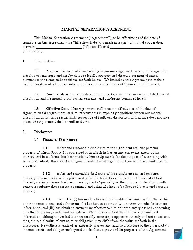
Find Fillable Letter of Intent
A letter of intent (LOI) is a preliminary agreement between two parties who want to continue their cooperation. This form provides an intent to do something and may serve different purposes, including purchasing goods or real estate, hiring or promoting employees, or suing someone. The form is non-binding, but it must be clearly outlined in the letter. Otherwise, a court may consider the agreement’s terms entirely enforceable should a dispute arise.
Popular Letter of Intent Templates
A letter of intent serves as a basis for further cooperation between parties. The parties sign the letter of intent to prove their good faith intention to arrange the deal. Although an LOI is usually non-binding, you should not underestimate it. This form is considered to be an essential legal instrument to formalize parties’ commitments.
One of the most common letters of intent is a Letter of Intent for Employment. It aims at expressing a person’s interest in working in a specific company or business. A letter of intent outlines the applicant’s key skills, characteristics, and accomplishments like a cover letter. Still, an LOI is more general and not used to apply for an available position.
If you want to notify your landlord about moving out of the premises, you should use a Notice of Intent to Vacate Template. This form is given within a certain period. Typically, you should send a notice of intent to vacate at least 30 days in advance. It provides a landlord with enough time to arrange everything and find a new tenant. However, the necessary time frame may be stated in your lease agreement.
A letter of intent is also used in transactions related to purchases. Thus, if you are going to purchase a house, you are encouraged to prepare a Letter of Intent to Purchase Real Estate. This Letter will establish the terms of the future purchase agreement, including purchase price, earnest money deposit, exclusivity and feasibility periods, and any representations and warranties by the seller.
A Letter of Intent for Purchase of Business is designed to outline the agreement terms related to the entity or business acquisition. The document proves the buyer’s serious intention to close the deal and makes the seller more likely to provide the buyer with warranties, an exclusivity period, and financing contingencies.
Another important LOI form is a Letter of Intent for Grant. It aims at generating interest in your project from a grant provider. This short letter of intent should communicate the main idea of your project, your contact details, company or organization description, its primary activities, and requested funding to achieve a certain result.
Letter of Intent Types
Letters of intent are used in a variety of situations. These types of letters precede binding agreements and help clarify the future terms of the deal. That’s why it’s an essential step in the direction of successful cooperation or transaction. Below you will find the list of different customizable letter of intent templates that may be adapted to your specific situation.
- Investment Letter of Intent Template
- Intent to Hire Letter
- Maternity Leave Letter to Employer
- Letter of Intent for a Job Promotion
- Letter of Intent Teaching
- Letter of Transfer
- Intent to Marry Letter
- Letter of Intent to Purchase Goods
- Commercial Lease LOI
- LOI Commercial Real Estate
- Letter of Intent to Lease
- Letter of Intent for School
- Homeschool Letter of Intent
- Internship Letter of Intent
- Letter of Intent for Medical School
- Residency Letter of Intent
- Pharmacy Residency LOI
- LOI for Scholarship
- Notice of Intent to Sue
Sample Letter of Intent (LOI):
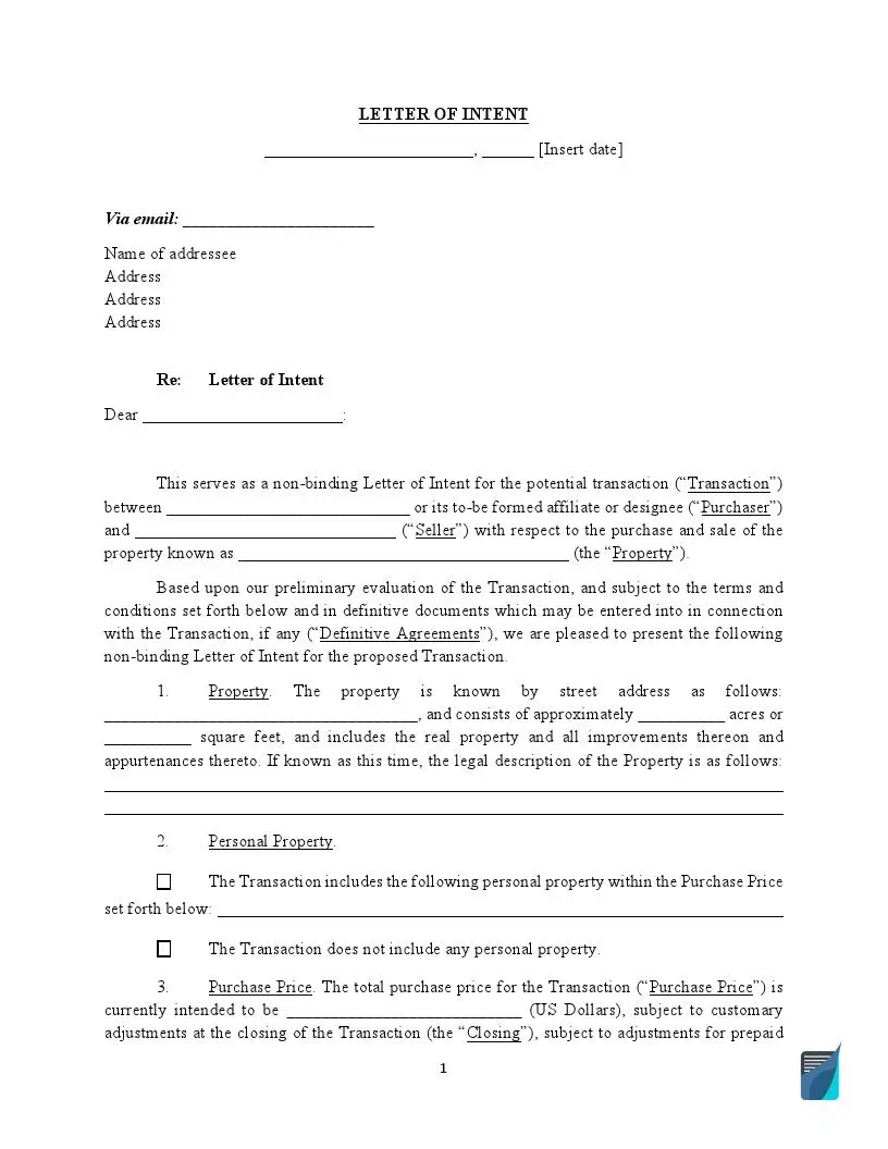
Find Fillable Deed Forms
Deed forms are used to transfer real property. The document is concluded between two parties – the grantor transferring the property and the grantee who’s receiving the title. All deed forms should include the parties’ names, transaction date, property and legal description of the property, and signatures. A deed form is usually signed only by the grantor, but some states require the grantee to sign as well.
The Most Widely Used Deed Forms
One of the most widely used deeds is a quitclaim deed form. It’s an easy way to transfer ownership from one party to another. However, this deed type does not guarantee that the person transferring the ownership is the only owner of the property. So, you should prepare this form carefully. A quitclaim deed is used mostly between people who can trust each other, such as family members or friends.
If you live in California, you can take advantage of California Quit Claim Deed Forms to prepare your document. California law requires you to provide some additional forms to record a quitclaim deed. Thus, you will have to file Form BOE-502-A (Preliminary Change Of Ownership Report) along with your deed. A California quitclaim deed must be signed in the presence of a notary public and recorded at the recorder’s office of the county where the property is located.
Another popular deed is a Lady Bird Deed Form, also known as an enhanced life estate deed. Using this deed form is a time-effective real estate planning method, as it allows your heirs to get your property without probate process after your death. But a ladybird deed is authorized only in several states, including Florida, Michigan, Texas, Vermont, and West Virginia.
A General Warranty Deed Form provides maximum legal protection when transferring real estate ownership. This form guarantees that the person who’s transferring the property owns it without any liens or mortgages. Unlike a quitclaim deed, a warranty deed is used when the grantee receives the real estate in exchange for money.
With a Texas Warranty Deed, you are transferring the ownership of the property that is located in Texas. This form is usually used in case of a real estate purchase. The grantor must sign a Texas warranty deed in the presence of two witnesses or a notary public and recorder at the county recorder’s office.
Deed Types
No matter what type of deed you use, they all should be recorded and attached to the real property, demonstrating who’s owned this property over time. You need to remember that some deeds offer more guarantees than others, so you should choose the document carefully. Additionally, each deed type may require you to include some specific components and attachments. For example, to record a transfer-on-death form, you may need to provide a copy of a person’s death certificate.
- Deed Forms
- Bargain and Sale Deed Form
- Correction Deed Form
- Trust Deed Form
- Fiduciary Deed Form
- Gift Deed Forms
- Deed in Lieu Form
- Limited Warranty Deed Form
- Transfer On Death Form
Sample General Warranty Deed:
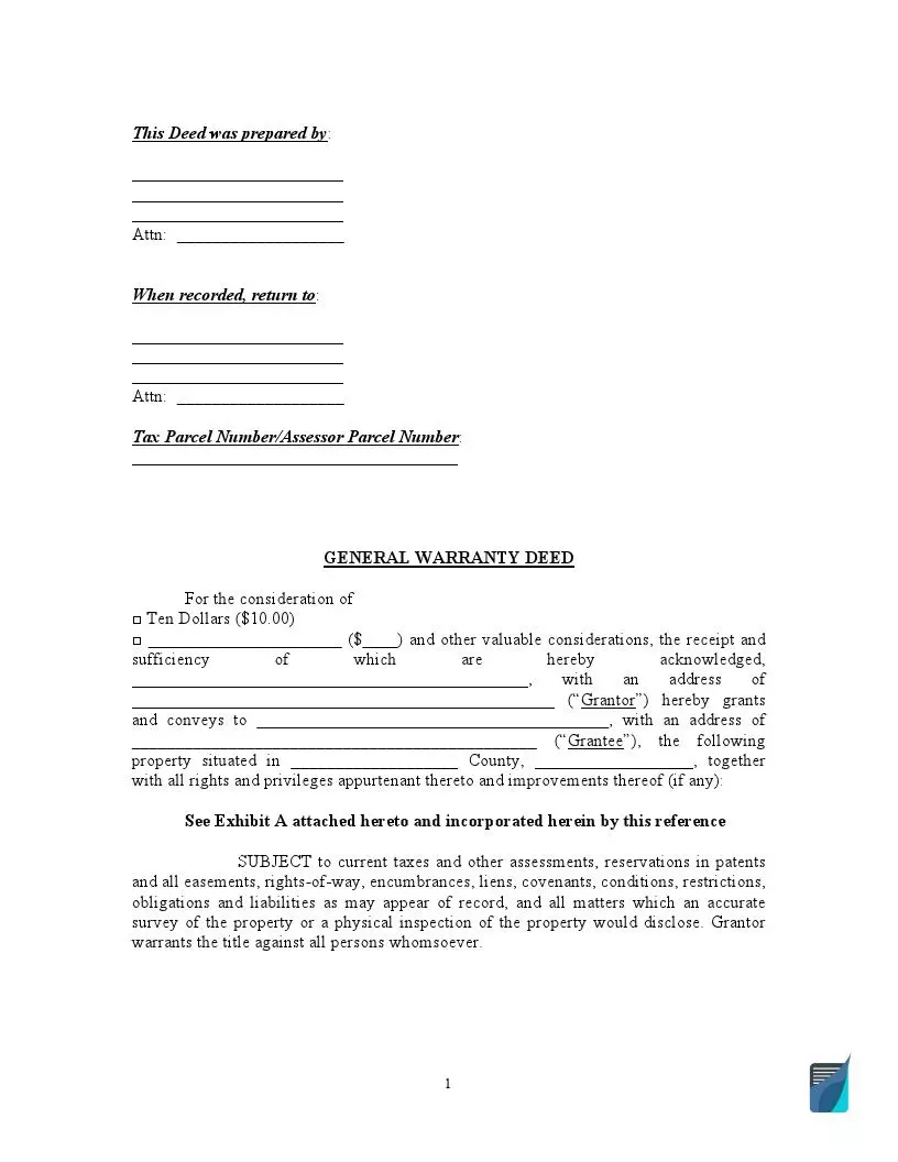
Deed Forms by State
Signing requirements for deed forms vary from state to state. In some states, you will need only a notary public to sign your deed, and in others, it’s required to have one or two witnesses. After your deed form is written and signed correctly, you will need to file the document with the recorder’s office. To transfer property using deeds, it’s crucial to obtain the state form where the property is located. Check the list below to find a deed template that can be used specifically in your state.
- Deed of Trust Form California
- Texas Deed of Trust
- Warranty Deed AZ
- Florida Warranty Deed
- Georgia Warranty Deed
- North Carolina General Warranty Deed Forms
- Lady Bird Deed in Florida
- Michigan Lady Bird Deed
- Lady Bird Deed TX
- Alabama Quit Claim Deed
- Arizona Quit Claim Deed
- Arkansas Quit Claim Deed Form
- Colorado Quit Claim Deed
- Florida Quit Claim Deed
- Georgia Quit Claim Deed Form
- Illinois Quit Claim Deed
- Indiana Quit Claim Deed Form
- Quit Claim Deed Form Kansas
- Maryland Quitclaim Deed
- Quitclaim Deed MA
- Michigan Quit Claim Deed
- Minnesota Quitclaim Deed
- Quit Claim Deed Missouri
- Nevada Quit Claim Deed Form
- New Jersey Quit Claim Deed Form
- New Mexico Quit Claim Deed Form
- Quit Claim Deed Form NY
- North Carolina Quitclaim Deed
- Quit Claim Deed Ohio
- Quitclaim Deed Oklahoma
- Pennsylvania Quit Claim Deed
- SC Quit Claim Deed
- Quitclaim Deed Tennessee
- Quit Claim Deed Texas
- Utah Quitclaim Deed
- Quit Claim Deed Form Virginia
- Quitclaim Deed Washington State
- Quit Claim Deed Form Wisconsin
- Special Warranty Deed FL
- Special Warranty Deed TX
- Beneficiary Deed AZ
- Transfer On Death Deed CA
- Colorado Beneficiary Deed
- IN Transfer On Death Deed
- Beneficiary Deed Missouri
- Texas Transfer On Death Deed
Find Fillable Affidavit Forms
An affidavit form is designed to confirm the written statement under oath. With this document, a person known as the affiant swears that every fact stated in the affidavit is accurate and true. Affidavit forms are binding legal documents and should not be taken lightly. They must be created voluntarily and signed in the presence of witnesses and a notary public. It’s crucial to have the appropriate affidavit template to get a high-quality valid document. And we’ve got it covered for you.
The Most Widely Used Affidavit Forms
An affidavit form is used every time a person needs to prove the authenticity of specific facts. You can use it to verify your or another person’s identity, notify about a person’s death, certify the name change, or confirm your place of residence.
Often, people marry United States citizens to obtain U.S. permanent residence. That’s why the U.S. Citizenship and Immigration Services (USCIS) places the conditions on such residence. These conditions can be removed only after two years of marriage by filing Form I-751 (Petition to Remove Conditions on Residence). In order to prove the reliability of marriage and avoid extensive interviews, the couple is recommended to attach an Affidavit of Friends, also known as Letter of Support for I-751, when filing their documents. This affidavit is prepared by people who know the couple well enough to vouch for the validity of their marriage.
An Affidavit of Heirship Form will come in handy when you need to identify yourself as the heir of the person who dies without a will. This affidavit type is a cost and time-effective way to quicken the probate process and distribute the decedent’s property and assets among beneficiaries as soon as possible.
You should use a Residency Affidavit to prove that you live at an indicated address. A residence is considered an apartment or house that can be owned or rented for a long period of time. An affidavit of residence is usually required by the Department of Motor Vehicles (DMV) to apply for a driver’s license.
Using an Affidavit of Service Template, you can create a legal document confirming that a person received specific legal documents from you. This form is frequently used in court proceedings and legal disputes. An affidavit of service should always contain the description of documents, when, how, and where they were delivered, and who is responsible for the delivery.
Sample Affidavit of Residency:
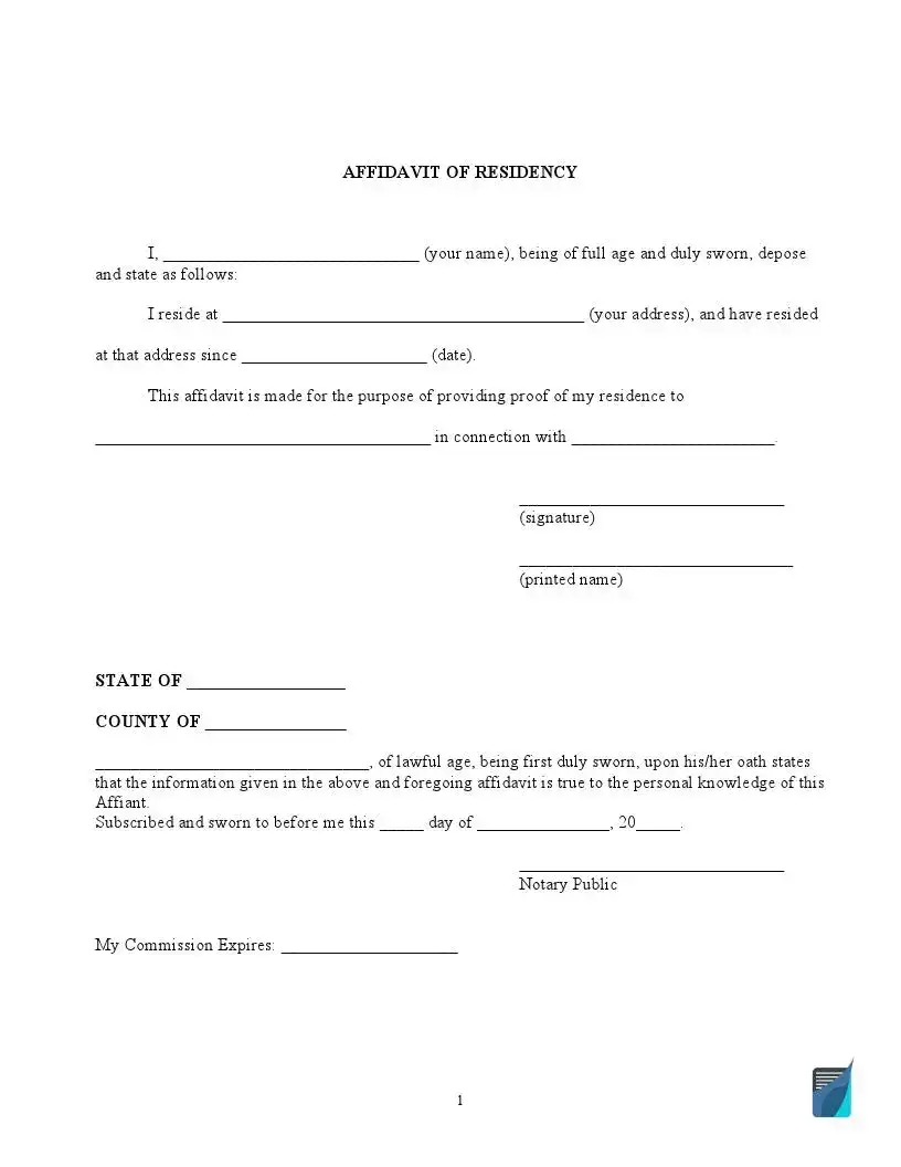
Affidavit Types
An affidavit can be used for various purposes. But each affidavit should include the following information: affiant details, written statements declared to be true, witnesses and notary acknowledgments, and other relevant attachments supporting the statements.
- Affidavit of Correction Title
- Affidavit of Death Form
- Domicile Affidavit
- Affidavit of Identity Form
- Gift Affidavit Form
- Financial Affidavit Form
- Scrivener’s Affidavit
- Affidavit of Indigency
- Birth Affidavit
- Single Status Affidavit
- Affidavit of Affixture
Find Fillable Loan Agreement Forms
A loan agreement is designed to protect the money borrowed from the lender. As additional protection, the lender can use a secured loan agreement. The secured agreement includes collateral—any borrower’s property of a high value, for example, a car or house. If the borrower fails to pay the required amount, the lender will seize the collateral. This can make the borrower more inclined to pay the loan on time. However, even if the agreement is unsecured, it’s still binding, and if the borrower fails to pay, the lender can file a lawsuit. Whether a person wants to borrow or lend the money, the document will protect both parties and help maintain good relationships, especially when it comes to family or employee loans.
Loan Agreement Types
If you cannot pay the total amount of the loan at once, you can use a Payment Plan Template. This document allows you to pay the loan according to a payment plan established with your lender. The plan should include a repayment schedule convenient for both parties, for example, quarterly, monthly, or weekly payments. It also has to specify the payment method. A payment plan can come in handy to pay tuition, dental treatment, or past due rent. The agreement should contain details of lending and borrowing parties, debt, down payment, and repayment schedule.
A loan agreement can be used for private vehicle sales, allowing buyers to pay the purchase price in installments. This loan agreement is called a Car Sale Contract with Payments (or Vehicle Repayment Agreement). Apart from standard loan terms like parties’ contact details, loan amount, interest rate, and repayment schedule, the agreement must include the vehicle description—its make, model, year of manufacturing, color, and the vehicle identification number (VIN). Such an agreement is an excellent option for individuals or families who need a car but cannot pay the total amount at once.
Many people think that it’s not necessary to sign an agreement when lending money from a family member or friend. However, it’s the case when you specifically need to consider concluding the agreement. Borrowing money is one of the common reasons why family members and friends become enemies. A Family Loan Agreement helps not spoil the relationships and provides greater family unity and respect among friends. The agreement outlines and clarifies the loan terms and ensures that the borrower will repay the money. The document can come in handy if you have a financial crisis and financial institutions refuse to give you loans. In this case, you can address the family that is more likely to help you out. Of course, it doesn’t mean that you will not have to pay the money back. But the agreement can define more flexible terms and lower interest rates for you as the borrower.
An IOU Template is a short and straightforward legal document stating that one party borrows money from another party and promises to repay them. The document contains the names of the lender and debtor, loan amount, due date, and sometimes repayment schedule. As a rule, an IOU form is used for a small amount of money and by people who can trust each other, for example, relatives or friends. Although an IOU is a simple document, it’s still legally binding and can be used as proof in court.
In case you need a guarantor for a loan, you may use a Personal Guarantee Template. A personal guarantor becomes responsible for the loan the same way as a borrower and is obliged to repay the loan if the borrower cannot. A personal guarantee covers the information about all the parties involved, including the lender, borrower, and guarantor. The document provides additional security for the lender. That’s why the lender may provide a lower interest rate or other benefits if the borrower has a personal guarantor.
If you need to pay tuition or medical expenses but don’t have the necessary money, you should consider borrowing from your employer. In order to ensure that everyone is on the same page and understands their obligations, you will need to sign an Employment Loan Agreement. The document includes all the necessary provisions to make the deal safe for both sides—parties’ contact information, loan amount, the amount deducted from the employee’s paychecks, the terms in case of a loan default, or if the employee quits, and parties’ signatures.
Other Fillable Forms
There are lots of other fillable forms that you can use for your business or personal purposes. The documents below are highly customizable templates covering various fields. Here, you will find purchase agreements, confidentiality and hold-harmless agreements, recommendation and resignation letters, and different employee forms.
- Articles Of Incorporation Template
- Business Plan Form
- Cease And Desist Letter Template
- Copyright Infringement Notice Template
- Confidentiality Agreement Template
- Consignment Agreement Form
- Corporate Bylaws Template
- DNR Form
- Employee Handbook Template
- Letter of Employment Verification
- Hold Harmless Agreement Template
- Indemnity Agreement
- Job Application Template
- Job Description Template
- Job Offer Letter Template
- Board Meeting Minutes Template
- Corporate Minutes Template
- LLC Minutes Template
- Non Profit Board Meeting Minutes Template
- Memorandum of Understanding Template
- BAA Template
- HIPAA Employee Confidentiality Agreement
- Mutual NDA
- Personal Financial Statement Template
- Privacy Policy Form
- Share Purchase Agreement
- Cash Receipt Template
- Recommendation Letter Template
- Resignation Letter Template
- Separation Agreement Template
- Website Terms And Conditions Template
- Liability Waiver Template
Fillable PDF Forms
You can also choose from our vast list of PDF forms divided into categories as a matter of convenience. The documents are customizable and can be created in minutes. Select the necessary category, fill out the form, and use your PDF document anywhere, regardless of device or internet access.
Internal Revenue Service (IRS) PDF Forms
IRS Form 1023
IRS Form 1023-EZ
IRS Form 1024
IRS Form 1040
IRS Form 1040-ES
IRS Form 1040-NR
IRS Form 1040-SR
IRS Form 1040-V
IRS Form 1040-X
IRS Form 1041
IRS Form 1042-S
IRS Form 1065
IRS Form 1094-C
IRS Form 1095-A
IRS Form 1095-B
IRS Form 1095-C
IRS Form 1096
IRS Form 1098
IRS Form 1098-E
IRS Form 1098-T
IRS Form 1099-A
IRS Form 1099-B
IRS Form 1099-C
IRS Form 1099-DIV
IRS Form 1099-G
IRS Form 1099-INT
IRS Form 1099-MISC
IRS Form 1099-R
IRS Form 1099-S
IRS Form 1099-SA
IRS Form 1120
IRS Form 1120-S
IRS Form 12153
IRS Form 12277
IRS Form 1310
IRS Form 13614-C
IRS Form 14039
IRS Form 2106
IRS Form 211
IRS Form 2210
IRS Form 2439
IRS Form 2441
IRS Form 2553
IRS Form 3520
IRS Form 3800
IRS Form 3911
IRS Form 3921
IRS Form 3949-A
IRS Form 4136
IRS Form 4137
IRS Form 433-A
IRS Form 433-A (OIC)
IRS Form 433-B
IRS Form 433-D
IRS Form 433-F
IRS Form 4361
IRS Form 4506
IRS Form 4506-T
IRS Form 4506T-EZ
IRS Form 4684
IRS Form 4797
IRS Form 4852
IRS Form 4868
IRS Form 4952
IRS Form 4972
IRS Form 5304-SIMPLE
IRS Form 5305-SEP
IRS Form 5329
IRS Form 5330
IRS Form 5405
IRS Form 5472
IRS Form 5498
IRS Form 5498-SA
IRS Form 5558
IRS Form 5695
IRS Form 6251
IRS Form 6252
IRS Form 656-B
IRS Form 6744
IRS Form 6781
IRS Form 7004
IRS Form 706
IRS Form 709
IRS Form 720
IRS Form 7200
IRS Form 8233
IRS Form 8282
IRS Form 8283
IRS Form 8300
IRS Form 8332
IRS Form 8379
IRS Form 8396
IRS Form 843
IRS Form 8453
IRS Form 8582
IRS Form 8655
IRS Form 8718
IRS Form 8801
IRS Form 8809
IRS Form 8814
IRS Form 8821
IRS Form 8822
IRS Form 8822-B
IRS Form 8829
IRS Form 8832
IRS Form 8840
IRS Form 8843
IRS Form 8853
IRS Form 8857
IRS Form 8862
IRS Form 8863
IRS Form 8867
IRS Form 8868
IRS Form 8879
IRS Form 8880
IRS Form 8888
IRS Form 8889
IRS Form 8917
IRS Form 8919
IRS Form 8936
IRS Form 8949
IRS Form 8959
IRS Form 8960
IRS Form 8962
IRS Form 911
IRS Form 940
IRS Form 941
IRS Form 941-X
IRS Form 9423
IRS Form 943
IRS Form 944
IRS Form 9465
IRS Form 966
IRS Form 990-EZ
IRS Form 990-PF
IRS Form 990-T
IRS Form SS-4
IRS Form SS-8
IRS Form W-10
IRS Form W-2
IRS Form W-2c
IRS Form W-3
IRS Form W-4
IRS Form W-4P
IRS Form W-4V
IRS Form W-7
IRS Form W-7 (COA)
IRS Form W-8BEN
IRS Form W-8BEN-E
IRS Form W-9
IRS Form W-9S
IRS Notice 1392
IRS Notice 703
IRS Schedule 1 Form 1040 or 1040-SR
IRS Schedule 2 Form 1040 or 1040-SR
IRS Schedule 3 Form 1040 or 1040-SR
IRS Schedule 8812 Form 1040
IRS Schedule A Form 1040 or 1040-SR
IRS Schedule A Form 990 or 990-EZ
IRS Schedule B Form 1040
IRS Schedule B Form 941
IRS Schedule C Form 1040
IRS Schedule D Form 1040 or 1040-SR
IRS Schedule E Form 1040
IRS Schedule J Form 1040
IRS Schedule K-1 Form 1041
IRS Schedule K-1 Form 1065
IRS Schedule K-1 Form 1120-S
IRS Schedule M-3 Form 1120
IRS Schedule O Form 990 or 990-EZ
IRS Schedule SE Form 1040
U.S. Citizenship and Immigration Services (USCIS) PDF Forms
USCIS Form I-130
USCIS Form I-134
USCIS Form I-485
USCIS Form I-589
USCIS Form I-864
USCIS Form I-9
USCIS Form N-400
USCIS Form N-648
Veterans Affairs (VA) PDF Forms
VA Form 10-2850a
VA Form 10-2850c
VA Form 10-5345
VA Form 5655
VBA VA Form 21-4138
VBA VA Form 21-526EZ
VBA VA Form 26-1880
VBA VA Form 28-1902w
United States Social Security Administration (SSA) PDF Forms
SSA 3373-BK
SSA 3380-BK
SSA Form SS-5
SSA Form SSA-44
SSA Form SSA-561-U2
SSA-3441-BK
SSA-795
United States Department of Defense (DOD) PDF Forms
DA Form 4856
DA Form 5960
DD Form 1351-2
DD Form 149
DD Form 2656
DD Form 2870
DD Form 93
Centers for Medicare & Medicaid Services (CMS) PDF Forms
CMS Form 1500
CMS L564-R297
CMS-40B
Form CMS-1763
Department of State (DS) PDF Forms
DS-11 US Passport Application
Form DS-3053
Form DS-82. US Passport Renewal Application
Other Fillable and Editable PDF Forms and Templates
2B Mindset Tracker
Acord 50 WM
Asurion F-017-08 MEN
ATF Form 4473
BBB Complaint Form
Birth Plan Form
Blank Coordinate Plane
Blank Marriage Certificate
Board Meeting Minutes Template
Bravecto Rebate Form
Bulletproof Diet Roadmap
Canada IMM 5257
CBP Form 6059B
CDC US Standard Certificate of Death
CDC US Standard Certificate of Live Birth
Coat of Arms Template
Community/Volunteer Service Verification Form
Costco Cake Order Form
DirecTV Channel Lineups
Doctors Excuse Note
Eagle Scout Project Workbook
Emotional Support Animal Letter
Fort Bend ISD Family Access Request Form
Gift Certificate Template
ICE Form I-983
Lyft Inspection Form
Medical Assisting Workbook Answers
MyAcuvue Rewards Submission Form
Obituary Template
Online Graph Paper
Prenuptial Agreement
Prescription Label Template
Pre Trip Inspection Checklist
PS Form 3575
Temporary Custody Form
T-Shirt Order Form
Utility Bill Template
Wedding Ceremony Script
Welp Hatchery
Willie Lynch Letter: The Making of a Slave
YMCA Member Cancellation Letter
Applications
AAA International Driving Permit Application
Application for Divorce
Autozone Credit Card Application
Boyfriend Application Form
Business Credit Application Template
Chick Fil a Job Application
Colleges Application Form
Cuddle Buddy Application
Dekalb County Water Application
DHSR/HCPEC-4515
Eagle Scout Rank Application
Employment Application Form
Girlfriend Application Form
International Driving Permit Application
Leap Application IML-4
Rochdale Village Application
Shark Tank Application
Tanzania Visa Application
Tennessee DHS Family Assistance Application
Trader Joe’s Application
Financial
ADP Pay Stub Template
Advance Beneficiary Notice of Non-coverage
AIA G702 G703
Apartment Lease Agreement
Auto Repair Estimate Form
Bill of Lading Form
Blank Invoice Template
Cash Drawer Count Sheet
Cash Receipt
Citibank Direct Deposit Form
Credit Report Dispute Form
Goodwill Donation Receipt
Independent Contractor Pay Stub Template
Order Form
Payroll Check Template
Profit and Loss Template
Purchase Order Form
Purchase Request Form
Roofing Estimate Template
Straight Bill of Lading Form
US Courts Form 271
US DoL WH-347
Local
CDSS Form SAR-7
Cornerstone Christian Correspondence School Transcript
DWC 250 Notice of Election to Be Exempt
EDD Form DE 2501
Form DL-43
Kern County Sheriff Restraining Order Form
LADBS NEC Standard Electrical Load Calculation
Louisiana Act of Donation
Mechanics Lien California
NJSP Form STS 033
NYC Disability Parking Permit
SJCERA Special Power of Attorney
Texas Law Help FM-DivC-100 Original Petition for Divorce Set C
Texas Nurse Aide Registry Form 5505-NAR
Texas Temporary Tag
TMRS Direct Deposit Authorization
TREC One to four family residential contract
TSBPE Plumbing Inspector Examination
Business
AIA A305 1986
AQHA Transfer Form
Construction Proposal Form
Gift Letter
HUD-1 Settlement Statement
SBA Form 413
Employment
Bio Data Template
Blank Resume Template
Employee Availability Form
Employment Verification Form
Fillable Pay Stub
Letter of Resignation
OPM Optional Form 306
OPM SF-15 Form
OPM SF-182 Form
Statement of Intent to Employ Minor
Time Card Template
Charts and Tables
52 Week Money Challenge
64 Team Double Elimination Bracket
96 Well Template
Check Register Template
DnD Character Sheet
Eco Map
Electrical Panel Schedule Template
Estimate Template
High School Transcript Template
Medevac Request Form GTA 08-01-004
Myers Briggs Compatibility Chart
NCAA Bracket
Packing List Template
Pedigree Chart
Prescription Pad Template
Yahtzee Score Card
Other OpenCongress Bills
S.968 – PIPA
This bill is designed to prevent online threats to economic creativity and theft of intellectual property and for other purposes.
It establishes a system for taking down websites that the Justice Department determines to be “dedicated to infringing activities.” The DoJ or the copyright owner would be able to commence a legal action against the alleged infringer and the DoJ would be allowed to demand that search engines, social networking sites, and domain name services block access to the targeted site. In some cases, action could be taken to block sites without first allowing the alleged infringer to defend themselves in court.
H.R.3261 – Stop Online Piracy Act
This bill would establish a system for taking down websites that the Justice Department determines to be dedicated to copyright infringement. The DoJ or the copyright owner would be able to commence a legal action against any site they deem to have “only limited purpose or use other than infringement,” and the DoJ would be allowed to demand that search engines, social networking sites, and domain name services block access to the targeted site. It would also make unauthorized web streaming of copyrighted content a felony with a possible penalty of up to five years in prison
Stop Online Piracy Act authorizes the Attorney General (AG) to seek a court order against a U.S.-directed foreign Internet site committing or facilitating online piracy to require the owner, operator, or domain name registrant, or the site or domain name itself if such persons are unable to be found, to cease and desist further activities constituting specified intellectual property offenses under the federal criminal code including criminal copyright infringement, unauthorized fixation and trafficking of sound recordings or videos of live musical performances, the recording of exhibited motion pictures, or trafficking in counterfeit labels, goods, or services.
H.R.3200 – America’s Affordable Health Choices Act of 2009
This bill seeks to expand health care coverage to the approximately 40 million Americans who are currently uninsured by lowering the cost of health care and making the system more efficient. To that end, it includes a new government-run insurance plan (a.k.a. a public option) to compete with the private companies, a requirement that all Americans have health insurance, a prohibition on denying coverage because of pre-existing conditions and, to pay for it all, a surtax on households with an income above $350,000.
America’s Affordable Health Choices Act of 2009 sets forth provisions governing health insurance plans and issuers, including:
- exempting grandfathered health insurance coverage from requirements of this Act;
- prohibiting preexisting condition exclusions;
- providing for guaranteed coverage to all individuals and employers and automatic renewal of coverage;
- prohibiting premium variances, except for reasons of age, area, or family enrollment; and
- prohibiting rescission of health insurance coverage without clear and convincing evidence of fraud.
H.R.45 – Blair Holt’s Firearm Licensing and Record of Sale Act of 2009
The Blair Holt’s Firearm Licensing and Record of Sale Act would establish a nationwide system for prohibiting unlicensed gun ownership. If approved, the law would require gun owners to apply for five-year licenses to own firearms and would give the U.S. Attorney General broad authority over the program.
Blair Holt’s Firearm Licensing and Record of Sale Act of 2009 amends the Brady Handgun Violence Prevention Act to prohibit a person from possessing a firearm unless that person has been issued a firearm license under this Act or a state system certified under this Act and such license has not been invalidated or revoked. Prescribes license application, issuance, and renewal requirements. Prohibits transferring or receiving a qualifying firearm unless the recipient presents a valid firearms license, the license is verified, and the dealer records a tracking authorization number. Prescribes firearms transfer reporting and record-keeping requirements. Directs the Attorney General to establish and maintain a federal record of sale system.
H.R.2454 – American Clean Energy And Security Act of 2009
This is the Waxman-Markey comprehensive energy bill, known for short as “ACES,” that includes a cap-and-trade global warming reduction plan designed to reduce economy-wide greenhouse gas emissions by 17 percent by 2020. Other provisions include new renewable requirements for utilities, studies, and incentives regarding new carbon capture and sequestration technologies, energy efficiency incentives for homes and buildings, and grants for green jobs, among other things.
American Clean Energy and Security Act of 2009 – Sets forth provisions concerning clean energy, energy efficiency, reducing global warming pollution, transitioning to a clean energy economy, and providing for agriculture and forestry-related offsets. Includes provisions:
- creating a combined energy efficiency and renewable electricity standard and requiring retail electricity suppliers to meet 20% of their demand through renewable electricity and electricity savings by 2020;
- setting a goal of, and requiring a strategic plan for, improving overall U.S. energy productivity by at least 2.5% per year by 2012 and maintaining that improvement rate through 2030; and
- establishing a cap-and-trade system for greenhouse gas (GHG) emissions and setting goals for reducing such emissions from covered sources by 83% of 2005 levels by 2050.
H.R.3590 – Patient Protection and Affordable Care Act
Patient Protection and Affordable Care Act – Title I: Quality, Affordable Health Care for All Americans – Subtitle A: Immediate Improvements in Health Care Coverage for All Americans – (Sec. 1001, as modified by Sec. 10101) amends the Public Health Service Act to prohibit a health plan from establishing lifetime limits or annual limits on the dollar value of benefits for any participant or beneficiary after January 1, 2014. It declares that a health plan shall not be prevented from placing annual or lifetime per-beneficiary limits on covered benefits that are not essential health benefits to the extent that such limits are otherwise permitted. Prohibits a health plan from rescinding coverage of an enrollee except in the case of fraud or intentional misrepresentation of material fact. Requires health plans to provide coverage for, and to not impose any cost-sharing requirements for:
- specified preventive items or services;
- recommended immunizations; and
- recommended preventive care and screenings for women and children.
H.R.3 – No Taxpayer Funding for Abortion Act
This bill would make permanent and expand the Hyde amendment restrictions on the use of federal funds for abortions. It seeks to prohibit even indirect funding streams that may potentially come in contact with abortion services. For example, it would deny tax credits to companies that offer health plans that cover abortions and it would block anybody with insurance that covers abortions from receiving federal subsidies or medical cost tax deductions, even if the abortion portion is paid separately with personal funds. Women who use tax-free Medical Savings Accounts would have to pay taxes on the costs of abortions.
No Taxpayer Funding for Abortion Act – Title I: Prohibiting Federally-Funded Abortions and Providing for Conscience Protections prohibits the expenditure of funds authorized or appropriated by federal law or funds in any trust fund to which funds are authorized or appropriated by federal law (federal funds) for any abortion. Prohibits federal funds from being used for any health benefits coverage that includes coverage of abortion.
S.773 – Cybersecurity Act of 2009
This is comprehensive legislation designed to address our nation’s vulnerabilities to cybercrime, global cyber espionage, and cyberattacks. It would establish a new Cybersecurity Advisory Panel within the White House and streamline the cybersecurity effort through all levels of government. The bill also calls on the Department of Commerce to establish and maintain a clearinghouse on information related to cybersecurity threats and vulnerability information to public and private infrastructure deemed “critical” by the President.
Cybersecurity Act of 2010 defines “cybersecurity” as “information security” which is defined (in federal code provisions related to the coordination of federal information policy) as protecting information and information systems from unauthorized access, use, disclosure, disruption, modification, or destruction in order to provide integrity, confidentiality, availability, and authentication, as those terms are further defined in specified federal code provisions related to information security. It defines “information system” as any equipment or interconnected system or subsystems of equipment that is used in the automatic acquisition, storage, manipulation, management, movement, control, display, switching, interchange, transmission, or reception of data or information, including certain industrial control systems.
H.R.4173 – Dodd-Frank Wall Street Reform and Consumer Protection Act
This is comprehensive legislation to overhaul regulations in the financial sector. It would establish a new Consumer Financial Protection Agency to regulate products like home mortgages, car loans, and credit cards, give the Treasury Department new authority to place non-bank financial firms, like insurance companies into receivership, regulate the over-the-counter derivatives market, and more.
Dodd-Frank Wall Street Reform and Consumer Protection Act – Title I: Financial Stability – Financial Stability Act of 2010 – Subtitle A: Financial Stability Oversight Council establishes the Financial Stability Oversight Council (Council), consisting of the heads of specified federal financial regulatory bodies and chaired by the Secretary of the Treasury. It requires the Council, among other things, to:
- identify risks to U.S. financial stability that could arise from the material financial distress or failure, or ongoing activities, of large, interconnected bank holding companies or nonbank financial companies, or that could arise outside the financial services marketplace;
- promote market discipline, by eliminating expectations on the part of shareholders, creditors, and counterparties of such companies that the Government will shield them from losses in the event of failure;
- respond to emerging threats to the stability of the financial system.
H.R.5175 – DISCLOSE Act
This bill seeks to increase the transparency of corporate and special-interest money in national political campaigns. It would require organizations involved in political campaigning to disclose the identity of the large donors and to reveal their identities in any political ads they fund. It would also bar foreign corporations, government contractors, and TARP recipients from making political expenditures.
DISCLOSE Act – Title I: Regulation of Certain Political Spending amends the Federal Election Campaign Act of 1971 (FECA) to prohibit:
- independent expenditures and payments for electioneering communications by government contractors if the value of the contract is at least $10 million;
- recipients of assistance under the Troubled Asset Relief Program (TARP) of the Emergency Economic Stabilization Act of 2008 (EESA) from making any contribution to any political party, committee, or candidate for public office, or to any person for any political purpose or use, or from making any independent expenditure or disbursing any funds for an electioneering communication; and
- persons who enter into negotiations for an oil or gas exploration, development, or production lease under the Outer Continental Shelf Lands Act from making any contribution to any political party, committee, or candidate for public office or to any person for any political purpose or use, or from making any independent expenditure or disbursing any funds for an electioneering communication.
S.3480 – Protecting Cyberspace as a National Asset Act of 2010
The bill creates the Office of Cyberspace Policy and National Center for Cybersecurity and Communications to set standards and coordinate cybersecurity efforts within the government. Gives the NCCC broad powers over “critical infrastructure” in the case of a “national cyber emergency”.
Protecting Cyberspace as a National Asset Act of 2010 – Title I: Office of Cyberspace Policy establishes in the Executive Office of the President an Office of Cyberspace Policy, which shall:
- develop a national strategy to increase the security and resiliency of cyberspace;
- oversee, coordinate, and integrate federal policies and activities relating to cyberspace security and resiliency;
- ensure that all federal agencies comply with appropriate guidelines, policies, and directives from the Department of Homeland Security (DHS), other federal agencies with responsibilities relating to cyberspace security or resiliency, and the National Center for Cybersecurity and Communications (established by this Act); and
- ensure that federal agencies have access to, receive, and appropriately disseminate law enforcement, intelligence, terrorism, and any other information relevant to the security of specified federal, military, and intelligence information infrastructure.
H.R.1 – American Recovery and Reinvestment Act of 2009
This is the economic stimulus package that was passed by Congress on Feb. 13, 2009, and signed into law by President Obama on Feb. 17. The final version is estimated by the Congressional Budget Office to cost $787 billion over the 2009-2019 period.
The bill amends the Federal Crop Insurance Act and the Trade Act of 1974 to extend the deadline for payment of a crop insurance-related fee by producers who suffered the crop year 2008 losses in order to qualify for certain supplemental agricultural disaster assistance for the crop year 2008. It makes FY2009 appropriations for farm operating loans. Directs the Secretary to use specified Commodity Credit Corporation (CCC) funds (to remain available until September 30, 2010) for state grants to eligible aquaculture producers for losses associated with 2008 high feed costs. It authorizes CCC fund use in FY2009 for administrative and salary purposes for certain programs established or amended under the Food, Conservation, and Energy Act of 2008.
S.978 – Commercial Felony Streaming Act
This bill makes unauthorized web streaming of copyrighted content a felony with a possible penalty of up to 5 years in prison. Illegal streaming of copyrighted content is defined in the bill as an offense that “consists of 10 or more public performances by electronic means, during any 180-day period, of 1 or more copyrighted works” and has a total economic value, either to the copyright holder or the infringer, of at least $2,500.
The bill amends the federal criminal code to provide for imprisonment for up to 5 years, a fine, or both, for criminal infringement of copyright where the offense consists of 10 or more public performances by electronic means, during any 180-day period, of one or more copyrighted works and where:
- the total retail value of the performances, or the total economic value of such performances to the infringer or to the copyright owner, would exceed $2,500; or
- the total fair market value of licenses to offer performances of those works would exceed $5,000. Includes, within copyright provisions protecting works from criminal infringement, the public performance of a work being prepared for commercial distribution.
H.R.847 – James Zadroga 9/11 Health and Compensation Act of 2010
This bill is designed to improve health services and provide financial compensation for 9/11 first responders who were exposed to dangerous toxins and are now sick as a result. It would establish a federal program to provide medical monitoring and treatment for first responders, provide initial health screenings for people who were in the area at the time of the attack and may be at risk, and reopen the 9/11 Victim Compensation Fund to provide compensation for losses and harm as an alternative to the current litigation system.
James Zadroga 9/11 Health and Compensation Act of 2010 – Title I: World Trade Center Health Program amends the Public Health Service Act to establish the World Trade Center Health Program (WTC Program) within the Department of Health and Human Services (HHS) to provide:
- medical monitoring and treatment benefits to eligible emergency responders and recovery and cleanup workers (including those who are federal employees) who responded to the September 11, 2001, terrorist attacks; and
- initial health evaluation, monitoring, and treatment benefits to residents and other building occupants and area workers in New York City who were directly impacted and adversely affected by such attacks.
S.510 – FDA Food Safety Modernization Act
The bill would increase the FDA’s regulatory authority over the food production system in order to prevent contamination and food-borne illness outbreaks. It would give the FDA mandatory recall authority, require food producers to have qualifying plans in place for identifying and addressing safety risks, require importers to verify the safety of all imported foods, and more. Small farms and food facilities that do less than $500,000 in sales annually and sell most of their food locally would be exempt from most of the new regulations in the bill.
FDA Food Safety Modernization Act – Title I: Improving Capacity to Prevent Food Safety Problems amends the Federal Food, Drug, and Cosmetic Act (FFDCA) to expand the food safety activities of the Secretary of Health and Human Services (HHS), including to authorize the Secretary to inspect records related to food. Exempts certain establishments that sell food directly to consumers, such as roadside stands, farmers markets, or participants in a community-supported agriculture program, from specified requirements of this Act. Requires each owner, operator, or agent in charge of a food facility to identify and implement preventive controls to significantly minimize or prevent hazards that could affect food manufactured, processed, packed, or held by such facility.
H.R.6304 – FISA Amendments Act of 2008
Foreign Intelligence Surveillance Act of 1978 Amendments Act of 2008 or FISA Amendments Act of 2008 – Title I: Foreign Intelligence Surveillance amends the Foreign Intelligence Surveillance Act of 1978 (FISA) to add a new title concerning additional procedures for acquiring the communications of certain persons outside the United States. Authorizes the Attorney General (AG) and Director of National Intelligence (DNI) to jointly authorize, for periods up to one year, the targeting (electronic surveillance) of persons located outside the United States in order to acquire foreign intelligence information, under specified limitations, including:
- prohibiting an acquisition intentionally targeting a person reasonably believed to be outside the United States in order to acquire the communications of a specific person reasonably believed to be inside the United States; and
- requiring the targeting to be conducted in a manner consistent with the fourth amendment to the Constitution.